2027 Best Geographic Information Systems (GIS) Degrees

Co-Founder and Chief Data Scientist
A Geographic Information Systems (GIS) degree is for students who want to use location-based data to solve practical problems, not just make maps. GIS connects geography, analytics, programming, remote sensing, environmental science, planning, logistics, public health, and emergency management. If you are comparing technology-focused degrees but also want work tied to real places, communities, infrastructure, climate, or natural resources, GIS can be a strong fit.
This guide explains what GIS students study, how long programs take, what they cost, which schools offer strong undergraduate options, and how to evaluate whether a GIS degree supports your career goals. It also covers jobs, salaries, specializations, financial aid, program-selection mistakes, and current trends such as artificial intelligence, cloud-based mapping, and interdisciplinary geospatial work.
Quick answer: Is a GIS degree worth considering?
A GIS degree can be worth considering if you enjoy data analysis, maps, technology, environmental or urban issues, and applied problem-solving. GIS researchers earn an average of $60,389 per year, and related occupations such as cartographers and photogrammetrists are projected to grow by 5% through 2030. The strongest outcomes usually go to students who build skills beyond basic mapping, including spatial analysis, database management, remote sensing, Python, R, visualization, and project communication.
What are the benefits of getting a GIS degree?
- It prepares you for several applied careers. Graduates may qualify for roles such as GIS specialist, GIS technician, cartographer, urban planning assistant, geospatial analyst, environmental consultant, or data-focused research assistant.
- It can lead to solid earnings. The average salary for GIS specialists in the U.S. is over $65,000, with some professionals earning 10% more in just five years.
- It supports work with real public impact. GIS is used in disaster response, infrastructure planning, climate tracking, land management, transportation, agriculture, logistics, and public health.
- It builds transferable technical skills. Students often learn spatial databases, data visualization, statistics, coding, and analytical communication, which can be useful in both public-sector and private-sector jobs.
What can I expect from a GIS degree?
A Geographic Information Systems degree teaches students how to collect, organize, analyze, and display location-based data. A typical bachelor’s program takes four years or about 120 credit hours, although some universities use quarter-based systems instead of semester credits. Coursework usually combines geography, statistics, computer science, environmental science, cartography, and data visualization.
Early courses often introduce mapping concepts, GIS software, physical geography, statistics, and data literacy. Advanced courses may cover spatial analysis, remote sensing, geospatial programming, database design, web mapping, and applied research methods. Many programs end with a capstone or senior project where students use geospatial tools to investigate a practical problem, such as flood risk, transportation access, land-use change, or public-service coverage.
Costs vary widely by institution. In-state students at public universities may pay around $12,000 per year, while private colleges can cost $40,000 or more. Students should compare total cost, not just tuition, because GIS programs may also require software access, lab fees, equipment, fieldwork expenses, textbooks, or paid data tools. Financial aid and departmental scholarships may reduce the final price.
Where can I work with a GIS degree?
GIS graduates work in organizations that need to understand where things are, how places are changing, and how spatial patterns affect decisions. Common employers include local, state, and federal government agencies; environmental consulting firms; transportation departments; utility companies; public health organizations; agriculture companies; real estate firms; defense contractors; and technology companies with mapping, routing, or location intelligence needs.
GIS professionals frequently collaborate with engineers, planners, emergency managers, scientists, surveyors, analysts, and policy teams. The work may involve building maps, cleaning spatial datasets, analyzing satellite imagery, modeling risk, supporting infrastructure projects, or presenting findings to decision-makers.
| Work setting | How GIS is commonly used | Good fit for students interested in |
| Government agencies | Transportation planning, zoning, emergency response, public works, land records | Public service, infrastructure, planning, policy |
| Environmental organizations | Habitat mapping, climate analysis, conservation planning, environmental impact studies | Sustainability, ecology, fieldwork, environmental data |
| Technology and logistics companies | Routing, location intelligence, delivery optimization, market analysis | Programming, analytics, business operations |
| Utilities and infrastructure firms | Asset mapping, network planning, risk assessment, maintenance tracking | Engineering support, systems, operations |
| Public health and research groups | Disease surveillance, service access analysis, demographic mapping | Health equity, research, statistics, community data |
How much can I make with a GIS degree?
GIS pay depends on the role, employer, location, experience level, and technical depth of the position. GIS specialists in the U.S. earn over $65,000 per year on average. Entry-level roles may begin in the $50,000 range, while experienced professionals in high-demand states such as California and Texas can earn well over $80,000.
Salary growth is often strongest for GIS professionals who can combine spatial analysis with programming, automation, database management, remote sensing, or data science. Skills in Python and R, experience leading projects, advanced degrees, and industry credentials such as the GISP can also improve competitiveness. Some experienced professionals in leadership, analytics, or specialized technical roles reach six-figure salaries, but outcomes are not guaranteed and vary by market.
- Best Geographic Information Systems (GIS) Degrees for 2027
- How long does a GIS degree take?
- How much does a GIS degree cost?
- What financial aid is available for GIS students?
- What are the admissions requirements for GIS programs?
- What courses do GIS majors take?
- What GIS specializations can students choose?
- Can a short-term technical degree complement a GIS background?
- How to choose the best GIS degree program
- What jobs can you get with a GIS degree?
- What is the GIS job market like?
- How can interdisciplinary studies amplify your GIS career?
- How is artificial intelligence reshaping GIS innovation?
- What trends are shaping GIS education and career success?
List of the Best Geographic Information Systems (GIS) Degrees for 2027
How do we rank the programs?
Research.com evaluates GIS degree options using trusted education and outcome data from the IPEDS database, Peterson's database, the College Scorecard database, and the National Center for Education Statistics. These sources help compare institutional quality, affordability, program structure, and student outcomes. Students should use rankings as a starting point, then verify curriculum fit, accreditation, transfer policies, cost after aid, internship access, and career support. For additional detail, see Research.com's methodology page.
1. University of California, Santa Barbara
UC Santa Barbara offers a BA in Geography with a focus on Geographic Information Science. The program is suited for students who want to apply spatial tools to topics such as sustainability, health, and climate. Its track-based structure lets students build skills in spatial analysis, cartography, and remote sensing while tailoring coursework to specific interests.
- Required Credits to Graduate: 180 quarter units
- Cost: $279 per unit (in-state), $1,073 per unit (out-of-state)
- Accreditation: WASC Senior College and University Commission (WSCUC)
2. The Ohio State University
Ohio State offers a GIS major that combines spatial data science, data modeling, map design, and communication. Students learn how to convert complex datasets into clear visual products and analytical insights that can be used across planning, research, public service, and private-sector projects.
- Required Credits to Graduate: 121
- Cost: $410.36 per credit hour (in-state), $1,190.92 per credit hour (out-of-state)
- Accreditation: Higher Learning Commission (HLC)
3. University of Washington – Seattle Campus
The geography program at the University of Washington allows students to study spatial issues through tracks such as GIS, data science, and sustainability. The program emphasizes analytical methods, including survey design and spatial statistics, which can support careers in research, public agencies, and applied data work.
- Required Credits to Graduate: 180 quarter credits
- Cost: $12,643/year (in-state), $42,501/year (out-of-state)
- Accreditation: Northwest Commission on Colleges and Universities (NWCCU)
4. University of Tennessee – Knoxville
The GIS and Technology program at UT Knoxville focuses on spatial thinking, technical practice, and applied problem-solving. Students prepare for work in public, private, and nonprofit settings through coursework that connects spatial science concepts with hands-on GIS applications.
- Required Credits to Graduate: 120
- Cost: Approx. $29,000/year
- Accreditation: Southern Association of Colleges and Schools Commission on Colleges (SACSCOC)
5. The University of Texas at Arlington
UT Arlington offers a GIS concentration within its Geology program. This option is a good match for students who want to combine Earth science with computer-based mapping, spatial data management, and analysis tools used in geoscience and other data-driven fields.
- Required Credits to Graduate: 120
- Cost: Approx. $25,900/year
- Accreditation: Southern Association of Colleges and Schools Commission on Colleges (SACSCOC)
6. University of Cincinnati
The University of Cincinnati is home to the Joint Center of Geographic Information Systems and Spatial Analysis. Students can access more than 70 GIS-equipped workstations and interdisciplinary lab environments while studying topics such as geography, remote sensing, environmental analysis, and geospatial methods.
- Required Credits to Graduate: 120
- Cost: $480 per credit hour (in-state), $1,050 per credit hour (out-of-state)
- Accreditation: Higher Learning Commission (HLC)
7. University of Texas at Dallas
UT Dallas offers geospatial science and remote sensing training across a full academic pathway from bachelor’s to Ph.D. Students benefit from a dedicated GIS department, applied coursework, and internship support designed to connect academic study with professional experience.
- Required Credits to Graduate: 120
- Cost: $360 per credit hour (in-state), $1,180 per credit hour (out-of-state)
- Accreditation: Southern Association of Colleges and Schools Commission on Colleges (SACSCOC)
8. University of Wisconsin – Madison
UW–Madison offers cartography and GIS training with access to modern labs, applied projects, and research opportunities. Experiences such as GIS Day Expo and community mapping projects help students build practical portfolios while developing technical and analytical depth.
- Required Credits to Graduate: 120
- Cost: $448 per credit hour (in-state), $1,502 per credit hour (out-of-state)
- Accreditation: Higher Learning Commission (HLC)
9. Arizona State University
ASU gives GIS students a foundation in spatial data, statistics, coding, and applied analysis before moving into advanced work involving environmental and social issues. The curriculum emphasizes practical problem-solving and may appeal to students who want flexibility or are considering dual-degree options.
- Required Credits to Graduate: 120
- Cost: $561–$661 per credit hour (depending on residency and program delivery)
- Accreditation: Higher Learning Commission (HLC)
10. CUNY Lehman College
Lehman offers a GISc program with flexible formats and connections to organizations such as NOAA and NASA. Students learn to analyze and map real-world problems, and many strengthen job readiness through internships and continued undergraduate-to-graduate study options.
- Required Credits to Graduate: 120
- Cost: $305 per credit hour (in-state), $620 per credit hour (out-of-state)
- Accreditation: Middle States Commission on Higher Education (MSCHE)
How long does it take to complete a GIS degree program?
Most bachelor’s degrees in GIS, geographic information science, geography with a GIS concentration, or related geospatial fields take about four years of full-time study. Shorter certificate options may take 6 to 12 months and are often designed for working professionals or students who already have a degree in another field.
| Program type | Typical completion time | Best for |
| Bachelor’s degree | About four years of full-time study | Students seeking entry-level GIS, mapping, planning, environmental, or geospatial analyst roles |
| GIS certificate | 6 to 12 months | Professionals adding GIS to an existing background in planning, engineering, environmental science, public health, or data analysis |
| Part-time study | Longer than full-time timelines | Students balancing school with work, family, military service, or other obligations |
| Online study | Varies by program pace and format | Students who need flexibility or cannot relocate for campus-based coursework |
Degree programs
A bachelor’s degree usually includes general education requirements, major courses, electives, and sometimes a capstone, internship, or research project. Students entering with transfer credits may finish faster if the receiving school accepts those credits toward the major and degree requirements.
Certificate programs
GIS certificates are narrower than full degrees. They typically focus on applied software, spatial analysis, cartography, remote sensing, and database skills. They can be useful for people who already work in public administration, environmental science, business analytics, surveying, logistics, or emergency management.
Full-time vs. part-time
Full-time enrollment is faster, but part-time study may be more realistic for working adults. Before enrolling part time, ask whether required GIS courses are offered every term or only once per year, because course sequencing can affect graduation timing.
Online learning
Online GIS programs can be convenient, but students should confirm software access, lab requirements, remote technical support, internship options, and whether the program includes hands-on projects that can become portfolio samples.
What is the average cost of a GIS degree program?
GIS program costs depend on school type, residency status, delivery format, program level, fees, and time to graduation. Certificates may cost a few thousand dollars, while bachelor’s degrees can cost tens of thousands per year depending on the institution.
Online certificates
Online GIS certificate programs typically cost between $15,048 and $18,810. These programs may be less expensive than a full degree because they require fewer courses, but students should still check technology fees, software requirements, and whether credits can later apply to a degree.
Bachelor's degrees
A GIS-related bachelor’s degree at a private university can cost $40,000 or more per year. Public universities are often less expensive for in-state students, while out-of-state tuition can be substantially higher.
Other cost factors to compare
- Residency status: In-state tuition at public universities is often lower than out-of-state tuition.
- Delivery format: Online programs may reduce commuting and housing expenses, but fees and software costs can still apply.
- Transfer credits: Accepted credits can shorten the program and reduce total cost.
- Technology expenses: GIS students may need a capable computer, software licenses, cloud storage, data access, or lab fees.
- Time to completion: Repeating courses, changing majors, or attending part time can increase total cost.
Students evaluating return on investment should compare program price with realistic job outcomes. Research.com’s guide on how to become a geographic information systems specialist can help connect academic planning with career preparation.
What are the financial aid options for students enrolling in a GIS degree program?
GIS students may qualify for the same broad financial aid options available to other undergraduates, including grants, scholarships, federal student loans, state aid, institutional awards, and work-study. Some schools also offer departmental scholarships for geography, geoscience, environmental science, cartography, or GIS students.
Students should complete required financial aid applications early and ask each school whether GIS majors are eligible for program-specific awards, research assistantships, paid internships, or fieldwork support. External awards can also help. For example, students can research Cartography & Geographic Information Systems Scholarships offered through academic and professional sources.
International students should review institutional aid policies carefully because eligibility can differ from domestic student aid. They may also want to investigate scholarships from home-country agencies, international foundations, and university offices that support global applicants.
What are the prerequisites for enrolling in a GIS degree program?
Most undergraduate GIS programs use admissions requirements similar to geography, environmental science, social science, or technology-related majors. Applicants are generally not expected to know GIS software before enrolling, but strong preparation in math, science, writing, and computer use can make the transition easier.
Helpful high school or prior college coursework may include algebra, statistics, earth science, environmental science, computer science, geography, and research writing. If an essay is required, students can describe interests in spatial data, mapping, community planning, climate, transportation, public health, technology, or environmental problem-solving.
Because GIS courses build on one another, students should take introductory mapping and data courses seriously. Foundational skills in coordinate systems, data quality, map interpretation, and basic analysis are essential before moving toward advanced work or a geospatial analyst career path.
What courses are typically in a GIS degree program?
A GIS bachelor’s degree typically includes around 120 credit hours over four years. Programs usually begin with general education and introductory geography or geospatial courses, then move into technical work in GIS software, spatial analysis, remote sensing, cartography, data management, and applied projects.
| Course area | What students learn | Why it matters |
| Introductory GIS | Basic mapping, layers, projections, spatial data types, GIS software workflows | Builds the foundation for all advanced GIS work |
| Statistics and spatial analysis | Pattern detection, spatial relationships, modeling, uncertainty, quantitative interpretation | Helps students move beyond map-making into evidence-based analysis |
| Cartography and visualization | Map design, visual hierarchy, labeling, symbols, dashboards, storytelling with data | Supports clear communication to nontechnical audiences |
| Remote sensing | Satellite imagery, aerial data, land cover, environmental monitoring | Useful in climate, agriculture, defense, conservation, and disaster analysis |
| Database and programming | Geospatial databases, scripting, automation, Python, JavaScript, web mapping | Improves technical competitiveness for analyst and developer roles |
| Capstone or internship | Applied project work for a real or simulated client | Creates portfolio evidence for employers |
Course emphasis differs by degree title. Geographic Information Science programs may include more database management, coding such as Python and JavaScript, and geospatial visualization. Geography programs may offer broader coverage of physical geography, climate, human geography, and environmental issues. Students interested in sustainability or conservation can compare GIS options with top environmental policy degree programs.
GIS also intersects with imaging, data interpretation, and spatial analysis in specialized technical fields. Students who are comparing applied technology pathways in healthcare may also review MRI technician programs, though MRI training and GIS training lead to different professional tracks.
What types of specializations are available in a GIS degree program?
GIS specializations help students align coursework with specific industries and job functions. The best choice depends on whether you want to work with environmental data, software systems, planning, imagery, public-sector services, logistics, or intelligence-related applications. Some specialization paths may also support preparation for credentials such as the GISP certification.
| Specialization | Main focus | Career direction it may support |
| Data Management | Designing, organizing, cleaning, and maintaining geospatial databases | GIS analyst, database technician, spatial data manager |
| Remote Sensing | Using satellite imagery, aerial imagery, and sensor data | Environmental analyst, imagery analyst, climate or agriculture support roles |
| Spatial Analysis | Using statistical and analytical tools to identify geographic patterns | Geospatial analyst, public health analyst, planning analyst |
| Cartography | Creating accurate, useful, and visually clear maps and geovisualizations | Cartographer, visualization specialist, GIS technician |
| Geographic Information Technology (GIT) | Web mapping, software development, system integration, automation | GIS developer, web mapping specialist, geospatial systems analyst |
Some universities also offer GIS electives tied to urban planning, public health, environmental science, homeland security, or geospatial intelligence. Internships, undergraduate research, and capstone projects can be just as important as the formal specialization because they help prove applied skills to employers.
Students interested in supply chains, routing, fleet planning, or warehouse location analysis may also explore how GIS overlaps with operations careers such as those described in Research.com’s logistics manager job description.
Can a Short-Term Technical Degree Complement a GIS Background?
A short-term technical credential can strengthen a GIS background when it adds a skill employers can clearly use. Cybersecurity, database administration, programming, cloud computing, statistics, and data analytics can all complement GIS because geospatial systems depend on reliable data, secure infrastructure, and technical integration.
This approach is most useful for students who already know the kind of GIS work they want to do. For example, cybersecurity knowledge may help in roles involving sensitive spatial data, infrastructure mapping, defense contractors, or secure public-sector systems. Students comparing technical credential options can review Research.com’s guide to jobs you can get with a 2-year cybersecurity degree and consider whether that pathway supports their GIS goals.
How to choose the best GIS degree program
The best GIS program is not simply the highest-ranked or most recognizable school. It is the program that matches your career target, budget, learning format, transfer situation, and technical interests. Some programs are rooted in geography and environmental science; others are more focused on programming, data science, remote sensing, or geospatial technology.
Questions to ask before choosing a GIS program
- Is the institution accredited? Confirm institutional accreditation before enrolling, especially if you plan to transfer credits, use financial aid, or attend graduate school later.
- Does the curriculum include current technical skills? Look for spatial analysis, remote sensing, databases, web mapping, Python, R, data visualization, and applied project work.
- Can you specialize? Choose a program with electives aligned to your target field, such as sustainability, planning, public health, logistics, or geospatial technology.
- Are internships or capstones built in? Employers often want proof that you can apply GIS tools to real problems.
- What software and lab access are provided? Ask whether you receive licenses, cloud tools, remote lab access, and technical support.
- How strong is career support? Look for employer partnerships, internship placement, alumni networks, portfolio guidance, and faculty connections.
- What is the true cost after aid? Compare net price, fees, housing, transportation, software, and the likely time to graduate.
Who should choose a GIS degree?
- Students who enjoy maps, data, technology, and real-world problem-solving.
- Students interested in environmental analysis, planning, transportation, emergency management, geospatial intelligence, or public-sector data.
- Students who want a technical degree but prefer applied spatial problems over purely abstract computing work.
- Students willing to build a portfolio and learn software, statistics, and at least some programming.
Who might consider a different path?
- Students who dislike data cleaning, technical troubleshooting, or computer-based analysis.
- Students seeking a licensed profession should verify whether GIS alone meets their requirements; some roles in planning, engineering, surveying, or environmental work may require additional credentials.
- Students focused primarily on software engineering may prefer a computer science degree with GIS electives or projects.
- Students focused mainly on conservation policy may compare GIS with environmental studies, planning, or environmental data analyst career path preparation.
Common mistakes when choosing a GIS degree
| Mistake | Why it can hurt you | Better approach |
| Choosing based only on rankings | A highly ranked school may not offer the specialization or format you need | Compare curriculum, projects, cost, internship access, and faculty expertise |
| Ignoring accreditation | Unaccredited study can create transfer, aid, and graduate-school problems | Verify accreditation before applying |
| Looking only at tuition | Fees, software, housing, and delayed graduation can raise total cost | Calculate net price and total degree cost |
| Assuming all GIS programs are technical enough | Some programs may emphasize theory more than tools employers request | Review course descriptions for coding, databases, remote sensing, and applied labs |
| Skipping portfolio-building opportunities | Graduates may struggle to prove skills with coursework alone | Prioritize capstones, internships, research, and public-facing project samples |
What career paths are available for graduates of a GIS degree program?
GIS graduates can pursue technical, analytical, design, planning, and research-oriented roles. Some jobs are available with a bachelor’s degree, while others may require additional experience, certifications, graduate study, or domain expertise in areas such as environmental science, urban planning, public health, engineering, or data science.
| Career path | Average annual salary | Typical responsibilities |
| GIS Technician | $51,490 | Creates and updates maps, maintains spatial databases, prepares datasets, and supports analysts or project teams using GIS software. |
| CAD Technician | $56,189 | Develops digital drawings and schematics for engineering, construction, architecture, or infrastructure projects. |
| Geospatial Engineer | $47,729 | Uses mapping technologies to evaluate terrain, infrastructure, and spatial conditions, often in sectors such as defense or mining. |
| Crime Analyst | $65,124 | Uses data, maps, and analytical tools to identify crime patterns and support law enforcement planning. |
| CAD Designer | $64,620 | Creates 2D and 3D models, plans, and technical drawings for structures, systems, machinery, or built-environment projects. |
Advanced or adjacent careers may require more preparation. For example, environmental scientist, urban planner, geospatial intelligence analyst, GIS developer, or project manager roles may involve graduate study, technical certifications, regulatory knowledge, or field-specific experience. Students who want to combine GIS with environmental engineering can also compare how added technical training may influence an environmental engineer salary.
GIS can also support logistics and operations roles because organizations use spatial data to improve routing, facility location, service coverage, and distribution planning. Students interested in that direction can review Research.com’s guide discussing logistics manager salary considerations and related analytical responsibilities.
What is the job market for graduates with a GIS degree program?
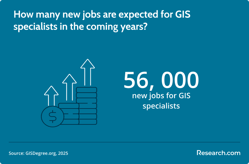
The GIS job market is supported by continued demand for location-based analysis in planning, infrastructure, emergency response, environmental monitoring, defense, logistics, utilities, public health, and technology. According to the U.S. Bureau of Labor Statistics, related roles such as cartographers and photogrammetrists are projected to grow by 5% from 2022 to 2032, about as fast as the average for all occupations.
Competition and opportunity vary by role. Basic map-production jobs may require strong software accuracy and attention to detail, while higher-paying analyst, developer, and data science roles often expect programming, database, automation, modeling, and communication skills. Employers commonly value GIS candidates who can explain not only what a map shows, but why the pattern matters and what decision it supports.
Employers that commonly hire GIS graduates
- Government agencies: Transportation, emergency management, land records, public works, planning, public safety, and environmental regulation.
- Environmental consulting firms: Impact assessment, habitat analysis, climate risk, conservation planning, and field-data management.
- Technology and mapping companies: Web maps, location-based services, routing, data visualization, and platform support.
- Utilities and infrastructure organizations: Asset mapping, network planning, outage response, and infrastructure risk analysis.
- Public health and community organizations: Service access, population trends, exposure mapping, and community needs analysis.
Students exploring healthcare-related technical jobs should understand that GIS and medical assisting are distinct pathways, though both may use data to improve service delivery. Research.com’s guide to CCMA jobs may help students compare healthcare credential options with geospatial careers.
How can interdisciplinary studies amplify your GIS career?
GIS becomes more powerful when paired with another discipline. A student who understands both spatial analysis and environmental policy can support conservation planning. A GIS graduate with programming skills can build web mapping tools. Someone with public health training can map service gaps or disease patterns. A background in logistics can support route optimization and site selection.
Interdisciplinary study works best when it is intentional. Rather than adding unrelated courses, choose a second field that connects to the problems you want to solve. Students interested in biological data, genomics, and complex datasets may compare geospatial study with an online masters program in bioinformatics, especially if they want to work at the intersection of data science, health, and research.
How is artificial intelligence reshaping GIS innovation?
Artificial intelligence is changing GIS by helping analysts process large spatial datasets, classify imagery, detect patterns, automate routine mapping tasks, and improve predictive modeling. In urban planning, environmental monitoring, transportation, and emergency management, AI-supported geospatial tools can speed up analysis and help organizations interpret complex location-based data.
AI does not remove the need for GIS judgment. Professionals still need to understand data quality, geographic context, bias, model limitations, ethical use, and how to communicate findings responsibly. Students who want stronger technical depth may explore advanced study options such as the cheapest online masters in artificial intelligence and evaluate whether AI coursework complements their geospatial goals.
What emerging trends are shaping GIS education and career success?
GIS education is increasingly shaped by cloud-based analysis, real-time spatial data, remote sensing, machine learning, web mapping, dashboards, automation, and large-scale data processing. Programs that update coursework around these tools can better prepare students for modern geospatial work, especially roles involving infrastructure, climate risk, logistics, disaster response, and public services.
Another major trend is interdisciplinary geospatial training. Employers often need professionals who understand both GIS tools and a domain such as geology, environmental science, data science, public health, planning, or business operations. Students interested in Earth systems, geoscience, and spatial field applications may compare GIS options with an online geology degree.
Key Insights
- GIS is broader than digital mapping. It combines spatial data, analytics, visualization, technology, and applied decision-making across many industries.
- A bachelor’s degree usually takes about four years. Certificate programs may take 6 to 12 months and can help professionals add GIS to an existing career.
- Costs vary widely. Online GIS certificates typically cost between $15,048 and $18,810, while private bachelor’s programs can cost $40,000 or more per year.
- Technical skills improve competitiveness. Programming, remote sensing, databases, spatial statistics, and portfolio projects can make a GIS graduate more marketable.
- Rankings are only a starting point. Students should verify accreditation, curriculum depth, internship access, total cost, software support, and career outcomes before enrolling.
- AI is changing GIS, not replacing it. Automation and machine learning can speed up analysis, but professionals still need geographic reasoning, data judgment, and communication skills.
- The best GIS path depends on your target field. Environmental work, logistics, public health, planning, defense, and software-focused GIS all require different elective choices and project experience.
References:
- Bureau of Labor Statistics. (n.d.). Geographers. U.S. Department of Labor.
- College Factual. (n.d.). Top ranked schools for geographic information science.
- GIS Degree. (n.d.-a). Bachelor’s in GIS programs.
- GIS Degree. (n.d.-b). GIS specialist career guide.
- Indeed. (n.d.-a). Types of jobs you can get with a GIS degree.
- Indeed. (n.d.-b). What does a GIS researcher do?
- Learn.org. (n.d.). What are the best GIS schools?
- University of Massachusetts Global. (n.d.). Guide to geographic information systems (GIS) degrees.
- University of Southern California. (n.d.). 4 reasons to consider GIS as a career.
Other Things You Should Know About GIS
Many accredited GIS bachelor’s programs require a capstone, while master’s programs often require either a thesis or a culminating project. Typical capstones are 3 to 6 credits and use tools such as ArcGIS Pro, remote sensing, and spatial analysis to show practical competence.
Prerequisites for enrolling in a GIS degree program in 2027 typically include a high school diploma with courses in mathematics and computer science. Some programs may require proficiency in software like ArcGIS or previous coursework in geography or related fields.