2027 Cheapest Accredited Online Geography Degree Programs: Tuition, Fees, and Financial Aid

Co-Founder and Chief Data Scientist
The cheapest accredited online geography degree is not always the one with the lowest tuition rate. Students also need to compare mandatory fees, transfer policies, residency rules, and financial aid. College Board reports that average published tuition and fees for in-state students at public four-year colleges reached $11,610 for 2024-25, making cost comparison more important.
This guide is for students seeking affordable online geography, GIS, or geospatial programs and explains how to identify true value by accreditation, total program cost, net price after aid, and realistic career fit.
Key Things You Should Know
- Among widely available accredited online geography and geospatial bachelor's options with clear published rates, UF Online and Fort Hays State University usually appear among the lowest-cost choices before aid, with published undergraduate online rates around $129.18 per credit for Florida residents at UF Online and $259.33 per credit at Fort Hays State University.
- A$129-per-credit program can become more expensive for nonresidents, while a higher flat online rate may be cheaper if it applies equally to all students and includes most mandatory fees.
- Net price matters more than sticker price because Pell Grants, state grants, institutional scholarships, employer tuition benefits, military benefits, and transfer credits can reduce what students actually pay out of pocket.
What Are the Cheapest Accredited Online Geography Degree Programs?
The cheapest accredited online geography degree programs are usually public university programs with regional institutional accreditation, transparent online tuition, strong transfer-credit policies, and limited mandatory fees. Because "geography" programs may be listed as geography, geospatial science, geographic information science, GIS, environmental geography, or earth systems programs, students should compare curriculum as well as price.
The table below highlights affordable accredited online options and cost benchmarks using published tuition information available from institutions for recent academic years. Estimated totals are before financial aid, books, transfer credits, residency discounts beyond those shown, and program-specific fees, so students should request a written cost sheet before enrolling.
| School | Online geography-related degree | Institutional accreditation | Published online tuition basis | Estimated tuition before aid | Cost note |
| University of Florida Online | BA in Geography | SACSCOC | About $129.18 per credit for Florida residents; higher nonresident rate | About $15,502 for 120 credits at the Florida-resident rate | Often one of the lowest sticker prices for eligible Florida residents, but nonresident pricing changes the comparison. |
| Fort Hays State University | Online geography or geosciences-related bachelor's pathway | Higher Learning Commission | About $259.33 per credit for online undergraduate students | About $31,120 for 120 credits | A flat online rate can be attractive for nonresidents because the published rate is not limited to in-state students. |
| South Dakota State University | Online geography or GIS-related bachelor's coursework/pathway | Higher Learning Commission | Public university online undergraduate tuition varies by residency and delivery category | Usually mid-range compared with the lowest flat-rate options | Students should confirm whether the full major can be completed online and whether any campus or field requirements apply. |
| University of North Dakota | Online geographic information science-related bachelor's option | Higher Learning Commission | Online tuition is commonly priced per credit and may be similar for many distance students | Usually higher than Fort Hays but lower than many private online programs | Best for students who want a stronger GIS and geospatial technology focus. |
| Oregon State University Ecampus | BS in Geography and Geospatial Science | Northwest Commission on Colleges and Universities | Per-credit Ecampus tuition on the quarter-credit system | Often higher than the lowest-cost semester-credit programs | Can offer strong academic depth, but students should convert quarter credits carefully when comparing cost. |
| Arizona State University Online | BA in Geography or related online geography pathway | Higher Learning Commission | Per-credit online tuition, commonly published as a range | Often a higher sticker-price option | May still be worthwhile for students who value ASU's scale, advising, course availability, and employer recognition. |
For most cost-conscious students, the first shortlist should include programs that are accredited, fully online, FAFSA-eligible, and transparent about whether online learners pay in-state, out-of-state, or flat tuition. A student who already has many transferable credits may find that a slightly higher per-credit rate produces a lower total cost if the school accepts more credits toward the major.
Students comparing geography with related online pathways should also look at adjacent fields. For example, students who want design, land-use, and built-environment careers may compare a geography program with an architecture degree online, while students focused on environmental planning may prioritize GIS-heavy geography curricula.
How Were the Cheapest Online Geography Degree Programs Ranked?
The cheapest programs should be ranked by the total cost a typical student would pay to finish the credential, not by a single advertised tuition number. A fair ranking also has to separate programs that are genuinely online from programs that simply offer a few online geography courses.
A practical affordability ranking should weigh the following factors in order because each one affects the amount students actually pay before and after aid:
- Accreditation and Title IV eligibility, because students generally need an accredited, eligible institution to use federal financial aid.
- Published tuition per credit or per term, separated by in-state, out-of-state, and flat online rates.
- Mandatory fees, including distance-learning, technology, course, graduation, and transcript fees.
- Total credits required for the degree, including general education, major, elective, and residency-credit requirements.
- Transfer-credit acceptance, because accepted credits can reduce both tuition and time to completion.
- Availability of grants, scholarships, employer benefits, military benefits, and payment plans.
- Program quality indicators such as GIS coursework, faculty expertise, advising, internship options, completion support, and career outcomes.
This approach prevents a common mistake: ranking a program first because it has the lowest per-credit tuition while ignoring a high out-of-state rate, restrictive transfer rules, or a required campus component. Students considering a later graduate credential can also compare bachelor's costs with future study plans, including an online master that may shorten the timeline to advanced roles.
How Can You Verify the Accreditation of an Online Geography Degree Program?
Accreditation is the baseline protection when choosing an online geography degree. Institutional accreditation means a recognized accreditor has reviewed the college or university as a whole; programmatic accreditation is less common for geography degrees, although some related planning, education, engineering, or environmental programs may have separate field-specific reviews.
Students can verify accreditation with a short checklist before applying. This matters because accreditation can affect federal aid, transfer credit, graduate admissions, and employer recognition.
- Search the institution in the U.S. Department of Education's Database of Accredited Postsecondary Institutions and Programs.
- Confirm that the accreditor is recognized for institutional accreditation, such as SACSCOC, Higher Learning Commission, NWCCU, MSCHE, NECHE, or WSCUC.
- Check the school's own accreditation page and make sure the institution name matches the campus or online division offering the degree.
- Use the federal College Scorecard to confirm the institution participates in federal student aid programs if FAFSA funding is part of your plan.
- Ask admissions whether the online geography degree appears on the same transcript as the campus version and whether the program has any in-person requirements.
Red flags include vague claims such as "internationally accredited," missing accreditor names, pressure to enroll immediately, unclear transfer policies, or programs that cannot explain federal aid eligibility. If a school is accredited but the specific degree is newly launched, students should ask whether all required major courses are already available online in the expected sequence.
How Much Does an Accredited Online Geography Degree Really Cost?
An accredited online geography degree's real cost includes more than tuition. Tuition is the charge for instruction; mandatory fees are required charges added by the school; total program cost estimates the full degree before aid; financial aid includes grants, scholarships, work-study, and loans; net price is the amount left after grants and scholarships are subtracted.
The table below shows how the same advertised per-credit rate can lead to different cost outcomes. It is a simplified model for a 120-credit bachelor's degree, so students should replace the examples with each school's official cost sheet.
| Cost item | What it means | Why it changes affordability | What to ask the school |
| Tuition | Instructional charge per credit, course, term, or program. | A low resident rate may not apply to online nonresidents | Is this rate guaranteed for online students, and does it vary by residency? |
| Mandatory fees | Required charges for technology, distance learning, student services, courses, or graduation. | Fees can add hundreds or thousands over a full degree | Which fees are mandatory for every online geography student? |
| Books and software | Textbooks, GIS software, maps, data tools, lab materials, or subscriptions. | GIS-heavy courses may require hardware or software planning | Are GIS tools included, free, discounted, or separately purchased? |
| Transfer credits | Previously earned credits accepted toward the degree. | Each accepted credit can remove a future tuition charge | How many credits can transfer into general education, electives, and the major? |
| Net price | Estimated cost after grants and scholarships. | The lowest sticker price is not always the lowest out-of-pocket cost | What is my estimated net cost after FAFSA, state aid, and institutional aid? |
College Board's 2024-25 national tuition data helps explain why net price matters: published tuition and fees differ sharply between public in-state, public out-of-state, and private nonprofit colleges. For online geography students, that means the cheapest option may depend heavily on residency, transfer history, and grant eligibility rather than on the school's headline price alone.
Which Tuition Models Make Online Geography Degree Programs More Affordable?
Tuition model is one of the biggest affordability factors in online geography education. The same student may pay very different amounts depending on whether the school charges per credit, per term, flat online tuition, subscription tuition, or competency-based tuition.
The table below compares common tuition models and how they affect online geography students. Use it to identify which model fits your transfer credits, work schedule, and expected pace.
| Tuition model | How it works | Best fit | Main affordability risk |
| Per-credit tuition | Students pay for each credit attempted | Part-time students or those using transfer credits | Repeating or withdrawing from courses increases cost. |
| Flat online tuition | Online students pay one published rate regardless of residency | Nonresidents comparing public universities | Mandatory fees may still vary by course or program. |
| In-state and out-of-state tuition | Residents receive a lower public-university rate | Students attending their home-state public university | Nonresident online learners may pay much more. |
| Flat-rate term tuition | Students pay one term price for a credit range | Full-time students who can handle a heavier load | Dropping below the credit threshold can reduce the value. |
| Competency-based tuition | Students progress by demonstrating mastery, often by term | Experienced adults with prior knowledge | Not widely available for pure geography degrees. |
Per-credit tuition is usually easiest to compare, but it can penalize students who change majors or repeat GIS courses. Flat online tuition can be especially useful for nonresidents if the school is accredited and the degree is fully online.
Students evaluating pace should also compare accelerated models in other fields to understand workload trade-offs. For instance, an accelerated psychology bachelor's degree online may show how faster completion can save tuition but increase weekly study demands.
What Fees and Hidden Costs Should Online Geography Degree Students Expect?
Fees and hidden costs can change the affordability ranking of online geography programs. Geography and GIS courses may involve technology platforms, mapping software, datasets, field exercises, or proctored exams, so students should ask for a complete fee schedule rather than relying on tuition alone.
Before choosing the lowest-cost program, review the following cost categories and ask whether each is required, optional, one-time, or recurring:
- Distance-learning or online course fees charged per credit or per course.
- Technology fees for learning platforms, student systems, or virtual lab access.
- GIS software, geospatial data tools, cloud storage, or specialized computer requirements.
- Books, digital materials, open educational resources, lab kits, or map supplies.
- Proctoring fees for online exams, especially in quantitative or GIS courses.
- Graduation, transcript, application, readmission, portfolio, and transfer-evaluation fees.
- Travel costs for any fieldwork, internship, campus orientation, or required in-person assessment.
A useful rule is to request a term-by-term estimate that includes tuition, required fees, materials, and expected graduation charges. If a school cannot provide that estimate, compare cautiously.
Students who are exploring geography because they like communication, places, people, and digital mapping may also compare adjacent online majors. Programs listed among the best colleges for social media marketing, for example, can be relevant for students interested in location-based marketing, tourism analytics, or digital audience mapping.
How Does FAFSA and Federal Financial Aid Work for Online Geography Degree Programs?
FAFSA is the main gateway to federal financial aid for eligible students in accredited online geography degree programs. Online students generally use the same FAFSA process as campus students, but aid eligibility depends on the institution, enrollment level, program eligibility, satisfactory academic progress, citizenship or eligible noncitizen status, and other federal rules.
The federal maximum Pell Grant for 2025-26 is $7,395. That figure is important because a Pell-eligible student at a low-tuition public online program may cover a meaningful portion of annual tuition with grant aid, while the same grant covers a smaller share at a higher-priced private or out-of-state program.
Use the following sequence to estimate aid before committing to an online geography degree:
- Confirm that the school and degree program are eligible for federal student aid.
- Submit the FAFSA as early as possible and list every school you are seriously considering.
- Compare financial aid offers by separating grants and scholarships from loans.
- Check enrollment requirements because half-time, three-quarter-time, and full-time status can affect aid amounts.
- Ask whether aid applies to summer terms, online fees, field courses, or required GIS materials.
- Calculate net price by subtracting grants and scholarships from tuition, mandatory fees, and required materials.
- Borrow only after comparing federal loan terms, monthly repayment estimates, and total debt at graduation.
Federal aid should be treated as a financing tool, not a sign that a program is automatically affordable. Students planning further education, such as the best EdD programs online for future education leadership roles, should be especially careful not to exhaust borrowing capacity during undergraduate study.
Which Scholarships, Grants, and Tuition Benefits Can Help Pay for an Online Geography Degree?
Scholarships, grants, and tuition benefits can make a higher sticker-price online geography program cheaper than a lower-tuition competitor. Grants are typically need-based and do not require repayment, scholarships may be need-based or merit-based, and tuition benefits are often provided by employers, military programs, states, or public-service organizations.
The table below summarizes common funding sources for online geography students and the cost question each source helps answer.
| Funding source | Typical basis | How it may reduce cost | Key question to ask |
| Federal Pell Grant | Financial need and federal eligibility | Reduces tuition and fee burden without repayment. | What is my annual Pell eligibility at this enrollment level? |
| State grants | Residency, need, enrollment, or workforce priorities | Can make an in-state public online program much cheaper. | Can online students use this grant at this school? |
| Institutional scholarships | Need, merit, major, transfer status, or academic performance | May reduce tuition each term if renewable. | Is the award renewable, and what GPA is required? |
| GIS or geography scholarships | Major, academic interest, service, or professional association criteria | Can offset major-specific costs such as software or conference fees. | Can online students in this major apply? |
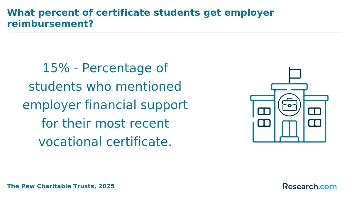
| Employer tuition assistance | Employment status and company policy | Can reimburse tuition after successful course completion. | Is reimbursement paid upfront or after grades are posted? |
| Military and veteran benefits | Service history, eligibility category, and school approval | May cover tuition, fees, housing allowance, or books depending on benefit. | Does the online program qualify under my benefit type? |
Students should prioritize free aid before loans and should confirm whether scholarships renew automatically. A common mistake is accepting a one-year award and assuming it will reduce the entire degree cost.
Career switchers should also look for employer-sponsored education in fields that use spatial data. Geography skills can support planning, logistics, market analysis, emergency management, environmental consulting, public health mapping, and transportation analysis, so tuition benefits may be available outside traditional geography departments.
Can Transfer Credits, Prior Learning, and Competency-Based Study Lower the Cost of an Online Geography Degree?
Transfer credits are often the fastest way to lower the cost of an online geography degree. If a student transfers 60 accepted credits into a 120-credit bachelor's program, the remaining tuition bill may be roughly half of the full sticker-price estimate, although major and residency requirements can limit savings.
Students should evaluate transfer and prior-learning rules before applying because each school decides how credits count. The steps below can prevent expensive surprises:
- Request unofficial transfer reviews from multiple accredited schools before paying an enrollment deposit.
- Ask how credits apply to general education, electives, prerequisites, and the geography major, not just how many credits transfer.
- Confirm the school's residency requirement, which is the minimum number of credits that must be completed through that institution.
- Check whether older credits, military training, professional certificates, AP, CLEP, DSST, or portfolio learning can reduce requirements.
- Ask whether GIS certificates, community college geography courses, statistics, environmental science, or computer science credits can satisfy major requirements.
- Compare the cost of retaking nonaccepted credits with the value of enrolling at a school with a more generous transfer policy.
Competency-based study can also lower costs when students move quickly through material they already know, but geography students should verify that the model includes enough GIS, spatial analysis, research, and applied geography coursework. A program that is cheaper but weak in geospatial skills may not be the best value for students targeting GIS-heavy roles.
Students considering graduate or professional pathways should preserve flexibility. For example, a bachelor's program with strong research, statistics, and spatial-analysis preparation may be more useful for later graduate study than the lowest-cost option with limited upper-division geography courses.
How Should Students Compare the Net Price, Quality, and Return on Investment of Online Geography Degree Programs?
Students should compare net price, academic quality, and return on investment together. A low-cost online geography degree is a strong value when it is accredited, affordable after aid, realistic to complete, and aligned with careers that use geographic, environmental, demographic, and geospatial analysis.
Use the following questions to compare final options. They are designed to reveal value differences that do not appear in tuition tables:
- What is the full estimated cost to graduate after transfer credits, mandatory fees, materials, and aid?
- Is the institution accredited by a recognized accreditor, and is the online program eligible for federal aid?
- Can the entire geography major be completed online, including upper-division courses and any capstone?
- Does the curriculum include GIS, remote sensing, spatial statistics, cartography, data visualization, environmental geography, or urban analysis?
- What advising, tutoring, library, software, career, and internship support do online students receive?
- What are the completion expectations for part-time students, working adults, and transfer students?
- How much debt would be required after grants, scholarships, employer benefits, and savings?
- Does the program support your target path, such as GIS technician, cartographer, planner, environmental analyst, logistics analyst, or graduate student?
BLS occupational data from 2024 shows that geography-related roles can vary widely in pay and job volume, with geographer roles smaller than broader fields such as urban planning, environmental science, and cartography. That means students should evaluate a geography degree by the skills it builds, especially GIS, data analysis, communication, and applied research, rather than by the major name alone.
The best-value choice is usually the accredited program with the lowest realistic net price that still offers the courses, support, and flexibility needed to finish. Paying somewhat more can be rational if the program accepts more transfer credits, offers stronger GIS preparation, provides better advising, or improves access to internships and employer-recognized projects.
Other Things You Should Know About Geography
Yes, if it comes from an accredited institution and the curriculum builds relevant skills. Employers usually care most about accreditation, GIS ability, data analysis, writing, research, internships, and project experience.
Many geography and GIS courses use mapping or geospatial software. Some schools provide licenses or cloud access, while others require students to meet hardware or software requirements, so ask before enrolling.
A geography degree can support GIS analyst roles if it includes GIS, cartography, spatial analysis, remote sensing, databases, and applied projects. Students targeting GIS jobs should review course titles and portfolio opportunities carefully.
A full 120-credit bachelor's degree often takes about four years for full-time students. Transfer students, part-time learners, and students taking summer courses may finish faster or slower depending on accepted credits and course availability.
References
- Costs of Online and Campus Colleges | University of Phoenix https://www.phoenix.edu/blog/comparing-the-costs-of-online-and-campus-colleges.html
- Private vs. Public Colleges: Differences, Pros & Cons https://collegewise.com/blog/private-vs.-public-colleges-differences
- Grants for college: a guide to how grants work + list of grants https://www.collegeessayguy.com/blog/grants-for-college
- Types of Financial Aid for Online Colleges https://www.umassglobal.edu/blog-news/types-financial-aid-online-colleges
- Top 10 Low-Cost Online Bachelor's in Geography https://www.greatvaluecolleges.net/rankings/online-bachelors-geography/
- Why Accreditation Matters | C-RAC https://www.c-rac.org/why-accreditation-matters
- Best Online Bachelor's Degrees in Geography - GISDegree.org https://www.gisdegree.org/online/bachelors-in-geography/
- 2025 Most Affordable Online Bachelor's Degrees https://www.onlineu.com/most-affordable-colleges/bachelors-degrees
- The Higher Education Accreditation Guide for Small and Mid-Sized Schools https://corecampus.com/higher-education-accreditation-guide/
- Accreditation And Online Colleges https://www.affordablecollegesonline.org/accreditation/