2026 Online Geographic Information Systems Master's Curriculum Breakdown: Core Courses & Specializations
Co-Founder and Chief Data Scientist
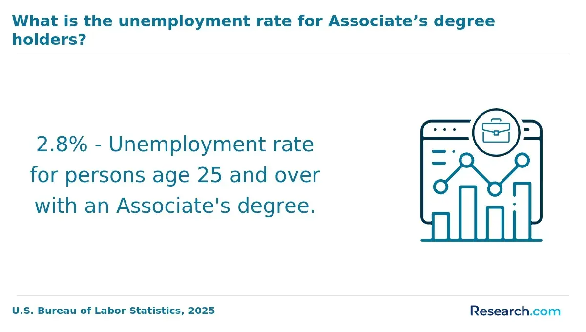
The evolving demand for precise spatial data analysis challenges online geographic information systems master's students to navigate curriculum structures with strategic foresight. Choices around specialization pathways influence not only immediate employability but also adaptability as sector needs shift, particularly amid growing integration of AI and cloud technologies reported by the U.S. Bureau of Labor Statistics in 2024.
Aligning core coursework with professional certification criteria can streamline credentialing but risks narrowing expertise. Meanwhile, sequencing constraints and theoretical gaps may hamper workforce readiness for applied roles. This article examines how program design, course selection, and focus areas collectively shape educational outcomes and viable career trajectories in GIS fields.
Key Things to Know About Online Geographic Information Systems Master's Curriculum
- Core courses emphasizing spatial analysis and data integration promote technical rigor but often limit elective flexibility, forcing students to prioritize foundational skills over niche specialization early in the program.
- Employers increasingly demand proficiency in emerging GIS technologies like real-time data analytics, reshaping core curricula to include these tools, which means graduates with outdated core skills may face diminished job competitiveness.
- Programs balancing synchronous and asynchronous delivery affect accessibility and pacing; recent 2024 data indicates 37% of students delay graduation due to rigid cohort models, highlighting a critical timing and cost tradeoff for working professionals.
What Core Courses Are Included in an Online Geographic Information Systems Master's Program?
The core curriculum structure in an online Geographic Information Systems master's program signals how rigorously a program aligns with employer expectations and practical GIS workflows rather than serving as a simple academic checklist. Candidates should anticipate an intensive integration of analytical, programming, and project-management competencies that underpin specialized GIS roles; mastering these foundational courses is essential before pursuing targeted concentrations or addressing sector-specific challenges.
The sequencing and workload in required courses for Geographic Information Systems master's program often reflect a tradeoff between broad theoretical grounding and early introduction to applied problem-solving, preparing students to meet a range of workforce demands.
- Spatial Data Analysis and Modeling: This course is central to developing competency in interpreting geographic data through statistical and predictive modeling techniques. Given that roughly 85% of geospatial professionals report regularly using spatial modeling in their daily work, according to a 2024 GIS Certification Institute survey, this course equips students with critical skills for uncovering spatial patterns and informing decision-making across environmental, urban planning, and public health domains.
- Geographic Information Systems Programming and Database Management: Emphasizing scripting languages like Python or R, this course addresses the operational necessity of automating complex spatial data workflows and managing geospatial databases. Mastery here supports efficiency gains and accuracy in large-scale GIS projects, which many employers prioritize as essential for advanced technical roles within the field.
- Remote Sensing and Image Analysis: Focused on interpreting data derived from satellite and aerial sources, this course delivers technical proficiency critical for applications in disaster management, environmental monitoring, and urban development. It bridges raw data acquisition with actionable insights and is increasingly crucial as spatial datasets grow more diverse and voluminous.
- Cartography and Visualization Techniques: Beyond basic map-making, this course instills design principles and technological fluency needed to communicate spatial data effectively. Clear visualization is often a decisive factor in translating complex GIS analyses for stakeholders and clients, aligning with employer expectations for professionals who can present data-driven insights clearly.
- GIS Project Management and Professional Practice: Addressing the soft skills and ethical frameworks required in GIS work environments, this course focuses on project planning, team collaboration, and professional standards. It ensures graduates can translate technical acuity into client-driven solutions while managing multifaceted projects-a capability increasingly sought after in multidisciplinary and applied GIS roles.
For prospective students evaluating how the online Geographic Information Systems master's core curriculum prepares them, considering how these courses interlock within the broader program structure is critical. These foundational components establish a baseline of operational skills enabling later specialization options and practical competencies demanded by the evolving geospatial workforce.
Some programs may incorporate additional electives or bridges into emerging GIS subfields, but the core ensures a solid analytical and technical starting point for addressing real-world spatial challenges. Those comparing programs may also consider workload sequencing and how foundational courses pace the transition toward advanced topics and specialization tracks.
For individuals balancing work or career transitions, understanding the nature of required courses for Geographic Information Systems master's programs is essential to gauge time commitments and skill integration paths. Programs with a clear, focused sequence of core courses facilitate better alignment with professional development goals and can complement hybrid or fully remote study models.
This nuanced awareness supports informed decision-making about program fit and specialization readiness, especially for career changers or specialization-focused learners looking beyond a generic academic framework.
Prospective students interested in additional flexible advanced degree pathways can also explore options like online EDD programs, which may share similar considerations around course sequencing and professional applicability in overlapping interdisciplinary fields.
What Specializations Are Available in Online Geographic Information Systems Master's Programs?
Specializations within online Geographic Information Systems master's programs are strategic choices that critically shape a student's marketability, skill complexity, and career trajectory. Selecting a focus area is less about academic labeling and more about aligning with workforce needs, which directly impacts competitiveness and workload intensity depending on the technical or applied nature of each specialization.
- Urban Planning and Smart Cities emphasizes applying spatial data toward infrastructure development and sustainable community design. Graduates are prepared for positions that integrate GIS with urban policy, requiring strong interdisciplinary collaboration and spatial reasoning tailored to municipal or regional planning agencies.
- Environmental Management focuses on natural resource monitoring, disaster mitigation, and compliance with environmental regulations. This track typically demands fieldwork or partnerships with agencies, equipping students with practical experience in ecological assessment and regulatory contexts, which employers highly value.
- Geospatial Data Science merges GIS fundamentals with advanced analytics, machine learning, and big data tools. A 2024 workforce study found candidates blending GIS with data science competencies have a 23% higher chance of employment in tech-centric roles, underscoring a shift toward interdisciplinary, analytically rigorous expertise. The tradeoff often includes more intensive computational coursework and less direct field application.
- Public Health GIS addresses spatial epidemiology and healthcare resource distribution, fields that have grown due to recent global health challenges. Graduates often collaborate with health organizations, leveraging geo-visualization and spatial statistics to influence policy and crisis response, aligning with rising demand across healthcare systems and NGOs.
Internship and practicum requirements further differentiate programs, with some tracks emphasizing hands-on fieldwork while others offer virtual projects focused on algorithmic development. These experiential components affect licensure potential and practical readiness, factors that prospective students should weigh alongside immediate career goals and employer expectations.
Can Students Choose Electives Outside Their Specialization?
Elective selection in online Geographic Information Systems master's programs is frequently governed by a combination of curriculum design, departmental policies, and sequencing requirements. Although many programs allow students to deviate from their specialization by choosing electives from other areas, this option typically requires advisor approval and adherence to prerequisite chains that ensure foundational competencies are met first.
Limited course availability and prioritization of core GIS offerings often restrict how many non-specialization electives a student can realistically take without extending their timeline. According to a 2024 national survey of graduate STEM programs, about 62% of GIS master's students reported having the option to take at least one or two electives outside their primary focus, yet this flexibility is usually bounded by structured degree progression to maintain academic rigor.
The decision to pursue electives outside one's specialization involves balancing greater interdisciplinary breadth against the risk of diluted technical depth that employers in specialized GIS roles often expect. Expanding into related fields like machine learning or environmental policy can enhance adaptability for broader job markets, but could also delay completion or require extra prerequisites, impacting financial and time resources.
For example, a student targeting a GIS analyst role may find tightly focused electives that reinforce spatial database management more beneficial than exploratory courses but might lose out on long-term managerial or cross-sector opportunities. Employers tend to favor graduates who demonstrate clear, specialized expertise, so elective choices must align strategically with intended career trajectories rather than personal curiosity alone.
One student recalled hesitating during the rolling admissions process while weighing options for electives outside their specialization. They worried approving advisors would reject requests for courses in remote sensing given their tight semester schedules and the prerequisite backlog.
Facing uncertainty about course availability and reluctant to delay graduation, the student finally opted for a more traditional GIS-centric path, feeling relieved yet mindful of missed interdisciplinary exposure that might have broadened future career opportunities.
How Are Online Geographic Information Systems Master's Courses Delivered?
Online geographic information systems master's courses predominantly combine asynchronous content with synchronous engagement to accommodate diverse student schedules and learning styles. A 2024 survey by the National Center for Education Statistics found about 72% of these programs use a hybrid delivery format, where learners access recorded lectures, datasets, and interactive mapping tools at their own pace but also participate in scheduled live discussions and collaborative sessions.
This structure fosters both independent study and real-time interaction, essential for mastering the complex spatial analysis and GIS programming tasks embedded in core coursework. Such delivery formats reflect a deliberate balance aimed at replicating professional GIS workflows while catering to flexible learning options for online geographic information systems degrees.
The varied pacing inherent in this hybrid approach presents both opportunities and challenges, especially for working professionals and career changers balancing study with existing responsibilities. Time management becomes critical when asynchronous modules demand self-discipline to keep pace, while synchronous components require a consistent presence to fully engage with faculty and peers.
This dual expectation can create stress points, particularly when live sessions involve group projects simulating real-world GIS applications. For many, the delivery format is a decisive factor influencing continuity in learning, skill acquisition, and ultimately degree completion.
While flexible schedules allow students to integrate coursework alongside professional duties, tradeoffs include potentially uneven participation and varied mastery of hands-on skills delivered through virtual labs or cloud-based software environments. Programs with optional in-person workshops or intensive skill labs try to mitigate these gaps but remain non-mandatory.
Prospective students should carefully weigh these dynamics, considering their own work-life balance and learning preferences, as the delivery model profoundly shapes not only academic performance but also the practical competence expected by employers. For those interested in exploring different educational pathways alongside specialized industry options, resources such as a business management degree online may offer complementary insights into balancing flexible learning with career ambitions.
Which Core Classes Are Considered the Most Challenging?
Core courses in online Geographic Information Systems master's programs that typically challenge students most are those steeped in quantitative and technical rigor. Spatial analysis and advanced geostatistics demand mastery of complex mathematical models and statistical reasoning that can overwhelm those without a solid quantitative foundation.
Remote sensing and image analysis add layers of technical difficulty, requiring familiarity with multispectral data and specialized software workflows. Programming and database management, particularly involving Python scripting and spatial databases like PostGIS, introduce further hurdles due to their hands-on coding requirements and ongoing troubleshooting challenges.
The difficulty in these courses is not merely academic; it directly influences student progression, specialization choices, and workforce readiness. According to a 2024 study by the National Center for Education Statistics, nearly half of GIS graduate students rank spatial analysis and geostatistics among their toughest subjects, underscoring widespread challenges in building essential technical skills.
For professionals juggling work and study, consistent practice in coding-intensive classes can delay timely degree completion and limit the ability to pursue more advanced roles in spatial modeling or data analysis. Balancing skill acquisition with career demands often forces students to weigh short-term academic strain against longer-term employment advantages in highly technical GIS positions.
One online GIS master's student described hesitating to submit an application while navigating rolling admissions, unsure if their prior coursework adequately prepared them for demanding core classes. They delayed enrollment briefly to strengthen their quantitative skills through targeted prep courses, fearing early failure might impede future specialization opportunities.
The student eventually entered the program with a clearer understanding of the workload but acknowledged the challenge of managing both skill gaps and professional responsibilities simultaneously.
Do Online Geographic Information Systems Master's Programs Require Internships or Practicums?
Requirements for internships or practicums in online geographic information systems master's programs vary widely, shaped by program design, accreditation standards, and the alignment with specific specialization tracks. Approximately 40% of these programs mandate experiential components, often through partnerships that facilitate supervised placements, while others integrate practical learning via capstone projects or simulation-based coursework, making internships optional or substitutable.
This variability reflects the tension between the logistical challenges of coordinating real-world fieldwork remotely and the educational value attributed to hands-on experiences by program developers. For students navigating online geographic information systems master's programs internship requirements, these differences mean the practical elements may function more as guided projects than traditional internships, depending on the institution.
The presence or absence of mandatory internships carries significant implications for working professionals and career changers balancing full-time jobs alongside study commitments. Programs requiring practicum placements sometimes extend completion times or compel geographic mobility to access quality opportunities, which can disrupt schedules but enhance job readiness, networking, and portfolio strength.
Conversely, those without such requirements offer flexibility but may limit direct exposure to workplace environments valued by employers. Data from the National Center for Education Statistics highlights this tradeoff, showing a marked gap between on-campus and online curricula in experiential learning mandates.
Prospective students should weigh these factors carefully against their experience levels and employment status, just as those evaluating a online master's in organizational leadership consider how curriculum shapes real-world applicability.
Which Courses Are Required for Professional Certification Exams?
Online Geographic Information Systems master's programs often structure required coursework to align tightly with the competencies evaluated in professional certification exams. Core subjects such as spatial analysis, remote sensing, cartography, and geospatial data management are deliberately mapped to certification domains emphasized by industry standards and bodies like the GIS Certification Institute or the American Society for Photogrammetry and Remote Sensing.
This alignment ensures that foundational knowledge corresponds directly to the technical and analytical skills measured by exams, while specialized courses reflect evolving professional expectations-for example, advanced geospatial programming or environmental GIS applications integrate emerging competencies demanded by the workforce. The deliberate competency mapping embedded in curricula facilitates a more efficient pathway for candidates to meet formal eligibility and preparation criteria grounded in recognized accreditation frameworks.
Deviating from these prescribed course sequences can have substantive consequences for certification timelines and career progression. Candidates who substitute or omit critical courses-such as spatial database design or ethical GIS practice-may find their eligibility delayed due to unmet academic prerequisites, requiring additional coursework or exam retakes.
For instance, a working professional who opts out of advanced remote sensing classes crucial for certain certification tracks might face extended preparation periods, impacting employer recognition and job prospects. According to a 2024 GIS Professional Workforce Alliance report, 78% of certified professionals credit participation in clearly aligned graduate coursework as a key factor in successful exam completion, underscoring the operational value of targeted curriculum choices.
Those evaluating programs should weigh how well course offerings correspond to certification requirements, balancing specialization interests against the practical necessity of fulfilling credentialing standards without undue delay or redundancy.
Do Specialization Requirements Extend Graduation Timelines?
Specialization requirements in online Geographic Information Systems master's programs often involve layered course sequences, prerequisite chains, and mandatory credit distributions that differ significantly from generalist tracks. These curricular structures can either maintain or extend the standard program length depending on how the specialization is integrated and the availability of required courses.
Many programs mandate capstone projects, applied research components, or internships tied specifically to the specialization, which may not align with core course schedules, resulting in potential delays. According to a 2024 study by the National Center for Education Statistics, about 37% of master's students pursuing specialized tracks face program extensions by one or two semesters compared to peers completing broad-based curricula.
Practically, specialization demands can create bottlenecks in course scheduling, where certain advanced classes have limited offerings or depend on earlier prerequisite completion, constraining student flexibility. For example, a working professional focusing on environmental GIS may find that delayed access to a key remote sensing course pushes back their capstone timeline, thereby affecting graduation and subsequent career entry.
Additionally, these requirements often limit elective substitutions, reducing the ability to balance workload with employment or personal commitments. Students must weigh enhanced technical expertise against the risk of delayed credentialing that may affect employer perceptions of learning agility and project management responsiveness in a competitive GIS job market.
How Do Geographic Information Systems Specializations Affect Career Opportunities?
Specializations within online Geographic Information Systems master's programs act as clear signals to employers, indicating a candidate's technical depth and practical focus. Recruiters often interpret a specific concentration-whether in remote sensing, spatial data science, or geospatial programming-as evidence of both relevant applied projects and aligned coursework, differentiating candidates in a competitive job market.
This targeted expertise aligns with sector-specific demands, allowing employers to predict readiness for specialized roles rather than general GIS positions. According to a 2024 report from the U.S. Bureau of Labor Statistics, graduates specializing in these areas typically experience a 12% higher employment rate within six months of graduation, underscoring the measurable impact GIS specialization has on job market growth.
However, specialization introduces tradeoffs between depth and breadth that affect real-world hiring dynamics. While a candidate focused on geospatial data analytics might quickly secure positions in public health or transportation analytics, broader GIS generalists retain flexibility for entry-level roles demanding foundational skills across industries.
For instance, a graduate concentrating in cartography may access government or environmental consultancy roles requiring strong visualization capabilities but may face challenges pivoting to data science roles without additional upskilling. Prospective learners and career changers evaluating online Geographic Information Systems programs should weigh this balance carefully, considering how their specialization aligns with their intended industry and affects long-term mobility.
Those interested in tailored career pathways might also find it useful to research online colleges for military transitioning to civilian GIS roles for relevant specialization options.
How Should Students Compare Online Geographic Information Systems Master's Curriculum?
Comparing online geographic information systems master's curriculum requires assessing tradeoffs in program structure that influence skill acquisition, time to degree, and job readiness. Differences in course sequencing, applied learning components, and specialization depth can substantially affect how well a program aligns with one's professional goals and scheduling needs.
Thoughtful evaluation reveals how curriculum design impacts not only knowledge breadth but also practical proficiency valuable to employers.
- Core Course Composition: Examine which foundational subjects are emphasized-such as spatial data analysis, remote sensing, or database management. Programs with a robust technical core paired with programming languages like Python or R typically enhance practical GIS skills demanded by the workforce.
- Specialization Depth and Relevance: Evaluate how in-depth specialization tracks align with targeted career paths, whether in urban planning, environmental GIS, or geospatial intelligence. Greater focus here can improve employability by matching evolving industry needs.
- Elective Flexibility: Consider if programs allow tailored electives that address emerging geospatial technologies or interdisciplinary areas like machine learning or public policy. Flexible curricula accommodate learners balancing work while preparing for diverse roles.
- Delivery Format and Scheduling: Assess availability of asynchronous coursework and project-based assessments which aid working professionals in managing workloads without compromising learning rigor.
- Experiential Learning Integration: Prioritize programs embedding internships, practicum opportunities, or capstone projects focused on real-world geospatial problems, which strengthen applied skills and employer connections.
- Certification Alignment: Review whether the curriculum supports preparing for relevant GIS certifications, an increasingly important credential in hiring decisions.
- Progression Sequencing and Time-to-Completion: Analyze how program pacing and credit requirements balance depth versus duration; some curricula enable accelerated paths while others emphasize thorough coverage, influencing how quickly students can enter the workforce.
According to the 2024 U.S. Bureau of Labor Statistics report on geospatial technology fields, graduates with hands-on GIS software expertise and programming skills experience a notable increase in employability during the first year after graduation. When weighing these factors, learners including career changers or seasoned professionals should consider how the curriculum design supports practical outcomes and fits their real-world constraints.
Prospective students might also compare related degree options, such as a bachelor of project management online, when exploring interdisciplinary pathways or supplemental skills adjacent to geographic information systems master's programs and specialization options.
What Graduates Say About Online Geographic Information Systems Master's Curriculum
- Kaiden: "During my master's specialization in geographic information systems, I quickly realized that practical experience carried more weight than just having a degree. Employers I interviewed with were deeply interested in my portfolio of spatial analysis projects and internships rather than formal licensure. This program helped me build a strong foundation, but landing my first role meant aggressively seeking out real-world applications of the skills I learned."
- Hank: "What stood out for me was the flexibility the geographic information systems program offered, allowing me to pivot my career from urban planning to remote sensing without delaying my entry into the workforce. Still, I found that salary growth was somewhat limited without additional certifications, and I had to be strategic about which skills to deepen to remain competitive for senior roles. It's a field with plenty of opportunity, but advancement sometimes requires balancing further training alongside work."
- Colton: "After completing core courses in geographic information systems, I realized that the hiring landscape was tougher than I expected, especially for government positions that favored candidates with professional licensure. That made me rethink my approach: instead of chasing titles, I focused on gaining certifications and freelance consulting experience. It's opened doors I wouldn't have gotten through traditional pathways, even if it means accepting different types of roles initially."
Other Things You Should Know About Geographic Information Systems Degrees
Flexibility varies widely across programs, with some offering asynchronous coursework and extended deadlines, while others require synchronous participation and fixed schedules. Working professionals should prioritize programs with asynchronous classes and modular exams to better integrate studies with unpredictable work hours. Rigid program structures often increase stress and risk delaying graduation, so reviewing course delivery methods upfront is critical for sustained progress without sacrificing job performance.
Employers increasingly favor specializations that combine technical GIS skills with data analytics, remote sensing, or programming. Selecting a specialization tied closely to these high-demand competencies enhances employability and salary prospects. Students should weigh labor market trends and choose specializations that balance their interests with clear career advancement pathways rather than opting solely for niche or legacy GIS roles with limited growth potential.
Project-based learning replicates real-world GIS challenges and significantly improves technical proficiency, problem-solving, and collaboration skills prized by employers. However, these projects often require substantial time investment and self-motivation, which can strain students balancing full-time jobs. Prospective students should assess program emphasis on applied projects since those with stronger practical components typically yield better portfolio development and immediate job-readiness.
Programs with a narrow technical focus develop deep software mastery but may limit exposure to broader spatial analysis, policy, or environmental contexts that enhance versatility in many GIS roles. This specialization can hasten entry into certain technical positions but reduce adaptability in shifting job markets. Students aiming for leadership or cross-sector roles should consider curricula that integrate technical training with applied social or environmental perspectives to maintain long-term career resilience.
References
- Geographic Information Systems | Free Online Course | Alison https://alison.com/course/advanced-diploma-in-geographic-information-systems
- Geographic Information Systems (GIS) - Claremont Graduate University https://www.cgu.edu/academics/program/geographic-information-systems/
- Want to be a GISP®? https://www.gisci.org/Want-to-be-a-GISP
- Guide to Geographic Information Systems (GIS) Degrees https://www.umassglobal.edu/blog-news/guide-geographic-information-systems-gis-degrees
- GIS careers and post-graduate programs - Don Boyes https://donboyes.com/gis-careers-and-post-graduate-programs/
- Geographic Information Science https://www.albany.edu/geographyplanning/programs/ms-geographic-information-science
- Best Masters in GIS Degree Programs Online for 2026 https://www.gisdegrees.org/programs/degree/masters
- Best Online Master's in GIS Programs - GISDegree.org https://www.gisdegree.org/online/masters/
- Postgraduate Program in Geographic Information Systems and Science https://novaims.unl.pt/en/education/programs/postgraduate-programs-and-master-degree-programs/postgraduate-program-in-geographic-information-systems-and-science/
- Best GIS Masters Programs in The World: Geographic Information Science Guide https://www.directionsmag.com/articles/best-gis-masters-programs-in-the-world-geographic-information-science-guide