2027 Cheapest Online GIS Bachelor's Degrees That Pay Well: Tuition, Duration, and Earnings

Co-Founder and Chief Data Scientist
The main question for many future GIS students is not whether geospatial skills are useful, but how to earn a recognized bachelor’s degree without taking on unnecessary debt. An online GIS bachelor’s program can help career changers, working adults, military students, and recent high school graduates build skills in mapping, spatial analysis, remote sensing, and geospatial data management while keeping work and family commitments in place.
Cost matters because GIS careers often reward technical ability, a strong portfolio, and a credible credential rather than an expensive campus experience. Approximately 40% of GIS job openings prefer candidates with a bachelor’s degree, so choosing an affordable accredited program can improve access to entry-level and advancement opportunities without overpaying for the credential.
This guide explains how to compare the cheapest online GIS bachelor’s programs by tuition, accreditation, transfer credit, completion time, financial aid, specialization options, and earning potential. The goal is to help you identify programs that are not only low-cost, but also practical, credible, and likely to support a strong return on investment.
Key Benefits of the Cheapest Online GIS Bachelor's Degree That Pays Well
- Online gis bachelor's degrees offer affordable tuition averaging 30-40% less than on-campus options, reducing overall student debt while maintaining accredited quality education.
- Flexible scheduling and transfer credit policies enable working professionals to accelerate skill acquisition without interrupting their careers, increasing timely graduation rates.
- Graduates frequently secure positions with median earnings over $60,000 annually, reflecting strong return on investment supported by industry demand and reputable program accreditation.
What Are the Most Affordable Accredited Online GIS Bachelor's Degree Programs Available Today?
The most affordable accredited online GIS bachelor’s programs combine low tuition with institutional accreditation, practical GIS coursework, and policies that help students finish efficiently. Accreditation should be the first filter because it affects federal financial aid eligibility, transfer credit, employer recognition, and access to graduate programs.
When comparing low-cost programs, look beyond the advertised per-credit rate. A program that accepts more transfer credits, offers year-round courses, or has lower fees may cost less overall than a program with a slightly cheaper tuition rate but fewer flexibility options.
- University of North Dakota: UND’s online bachelor’s in Geographic Information Science is accredited by the Higher Learning Commission and costs about $399 per credit. It is a strong option for students who want a recognized public university with industry-oriented GIS coursework.
- Western Carolina University: WCU’s online GIS program costs approximately $282 per credit hour for in-state online students. Its value comes from a hands-on GIS focus and transfer credit flexibility, which can reduce both time and cost for students with prior college coursework.
- Valdosta State University: Valdosta offers a geography bachelor’s degree with a GIS concentration at roughly $281 per online credit hour for in-state learners. The program is regionally accredited and may appeal to students seeking the best value online GIS bachelor’s degrees with financial aid options.
- Kentucky State University: KSU offers an accredited GIS degree costing about $350 per credit online. Its curriculum emphasizes practical mapping and spatial analysis skills, making it a cost-conscious option for students focused on workforce readiness.
- American Public University System: APU charges around $285 per credit for its accredited GIS specialization and is known for military-friendly policies, flexible pacing, and broad transfer credit acceptance.
These programs are worth considering because they address the three issues that most affect affordability: tuition rate, credit transfer, and program credibility. A cheaper program is not always the better choice if it lacks support, limits transfer credits, or does not align with your target career path.
Students comparing GIS with other career-oriented majors should focus on total net cost, not just advertised tuition. The best-value program is the one that gives you recognized credentials, relevant GIS skills, and a realistic path to graduation at the lowest total cost.
How Does Tuition Cost for Online GIS Bachelor's Programs Compare Across Public and Private Universities?
Public universities often appear cheaper than private universities because state funding helps reduce tuition for residents. However, the real comparison is more nuanced. Online GIS students should compare per-credit tuition, residency rules, transfer credit acceptance, required fees, and financial aid before deciding whether a public or private program is the better value.
- Per-credit tuition rates: Public universities usually charge lower rates for in-state students because state subsidies reduce sticker prices. Private nonprofit institutions often charge higher per-credit tuition because they rely more heavily on tuition revenue.
- Total program cost: A lower tuition rate does not automatically mean a lower total cost. Private universities may become competitive if they accept more transfer credits or offer generous institutional aid. Public universities may become more expensive for out-of-state online learners if non-resident tuition applies.
- State subsidy impact: State appropriations help public institutions keep tuition competitive for residents. Private institutions do not receive the same kind of state support, but they may offset costs through merit scholarships, need-based grants, or tuition discounts.
- Enrollment and program scale: Large public universities can spread online learning costs across many students. Smaller private programs may have higher administrative or technology costs per student, but some offer more individualized advising or a more specialized curriculum.
- Program delivery format: Asynchronous online courses can lower delivery costs and improve flexibility for working adults. Programs with more live sessions, faculty interaction, or specialized technology may cost more, but they may also provide stronger academic support.
- Financial aid and scholarships: Private nonprofit universities may offer aid packages that make their net cost comparable to, or sometimes lower than, a public option. Always compare the cost after grants and scholarships, not only the listed tuition.
The most practical approach is to ask each school for a complete cost estimate based on your transfer credits, residency status, expected enrollment pace, and financial aid eligibility. This is the same kind of cost-benefit comparison students should use when evaluating other online degrees, including accelerated psychology degree programs.
What Is the Typical Duration of an Online GIS Bachelor's Degree, and How Can Students Graduate Faster?
Most online geographic information system (GIS) bachelor’s degrees require approximately 120 credit hours. In a traditional full-time format, students complete the degree in four years across eight semesters. The timeline can be shorter or longer depending on transfer credits, course availability, enrollment pace, and whether the program offers accelerated or year-round options.
- Standard duration: A full-time student usually completes a 120-credit curriculum in four years by taking a balanced mix of general education, major, elective, and GIS-focused courses.
- Accelerated terms: Some schools divide the year into shorter eight-week sessions instead of traditional 16-week semesters. Southern New Hampshire University offers accelerated sessions that can help motivated students move faster, although the workload can feel intensive.
- Year-round enrollment: Taking courses during summer and winter terms can reduce downtime between semesters. Oregon State University is known for offering this option to help reduce time-to-degree completion.
- Competency-based learning: Self-paced, mastery-based formats allow students to progress by demonstrating skills rather than waiting for a fixed semester schedule. Western Governors University is an example of this approach for students who can move efficiently through material they already understand.
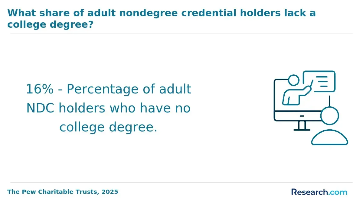
- Transfer credits: Prior college coursework, military training, CLEP, DSST, and prior learning assessments can shorten the degree if accepted by the school. Transfer policy is often one of the biggest factors in graduating faster.
- Cost savings: Finishing early can reduce tuition exposure, limit fees, and allow graduates to pursue GIS-related roles sooner. The savings are strongest when students accelerate without overloading themselves to the point of poor performance or course withdrawal.
A professional who enrolled in an online GIS bachelor’s program said flexibility was essential during his career transition. He noted that balancing coursework with full-time employment was challenging, especially during accelerated terms: “At times, the accelerated terms were intense, but they kept me focused.” He also valued being able to apply course concepts at work and move ahead when he was confident in the material. Looking back, he said, “Completing faster than the usual four years made a significant difference, especially financially and for my peace of mind.”
Which Online GIS Bachelor's Programs Offer the Best Earning Potential After Graduation?
The online GIS bachelor’s programs with the best earning potential are usually those that combine accreditation, technical depth, internship or project experience, and high-demand specializations such as geospatial analysis, remote sensing, and spatial data science. A low-cost program can produce strong ROI when it helps graduates qualify for roles in government, environmental consulting, planning, utilities, logistics, defense, or technology.
According to the Bureau of Labor Statistics Occupational Outlook Handbook, careers in surveying, cartography, and urban planning are common paths for GIS graduates, and median wages tend to grow with experience. Salary outcomes vary by employer, location, technical skill level, and specialization, so students should avoid choosing a program based on salary claims alone.
- Specialization hierarchy: Programs with geospatial data analytics, remote sensing, and spatial data science tend to support stronger earning potential than broad general GIS tracks because they build advanced technical skills valued by public and private employers.
- Demand-driven earnings: Urban and regional planning graduates may earn competitive wages because GIS skills are used in zoning, transportation, infrastructure, land use, and smart city development.
- Institutional success: Data from top-paying online GIS bachelor’s programs in the United States indicates that accredited programs with internship components often help graduates enter the workforce with salaries between $60,000 and $75,000 early on.
- Portfolio value: Employers often want evidence of applied skill. Capstone projects, web maps, spatial analysis samples, remote sensing work, and database projects can make a graduate more competitive than coursework alone.
- Flexible paths and accreditation: Recognized accreditation and transfer-friendly policies can help students complete the degree faster and enter the job market sooner, improving long-term income potential.
- Financial aid and ROI: Affordable tuition combined with grants, scholarships, and transfer credits can significantly improve return on investment by reducing debt. Students comparing degree costs across fields may find the cost of accounting degree online useful as a point of comparison for managing education expenses.
What Financial Aid and Scholarship Opportunities Are Available for Online GIS Bachelor's Students?
Online GIS bachelor’s students should start with the Free Application for Federal Student Aid (FAFSA). Filing the FAFSA determines eligibility for federal Pell Grants, subsidized loans, and other forms of aid. Grants are especially valuable because they do not need to be repaid, while loans should be used carefully after free aid has been maximized.
Accreditation is critical here. Students generally need to attend an eligible accredited institution to access federal financial aid. State grants, institutional scholarships, employer tuition benefits, military education benefits, and GIS-related scholarships can also reduce the net cost of a degree.
Specialized scholarships from geospatial organizations and nonprofits may help cover tuition, software, conference travel, or professional development. According to a recent College Board report, roughly 85% of undergraduates receive some form of financial aid, with aid covering about 60% of tuition on average. As online enrollment grows, nearly 40% of aid recipients in 2023 were fully online learners, showing that distance learners are increasingly included in aid programs.
- Federal aid access: FAFSA submission is the first step for Pell Grants and subsidized loans. Students should file as early as possible and review annual deadlines carefully.
- State and institutional grants: Some states provide grants for residents in accredited online programs. Colleges may also offer scholarships based on academic achievement, financial need, transfer status, military affiliation, or program of study.
- Professional scholarships: GIS-related associations and nonprofits may award scholarships to students pursuing geospatial education, especially those with strong academic records, career goals, or community impact.
- Employer support: Working adults should ask whether their employer offers tuition reimbursement or professional development funding, especially if GIS skills support the organization’s mapping, logistics, environmental, planning, or data needs.
- Prioritize free aid: Grants and scholarships should come before loans. Borrow only what is needed, and compare expected monthly repayment with realistic entry-level earnings.
- Growing online support: With more students earning degrees online, financial aid offices are increasingly familiar with the needs of fully online learners.
A professional who completed an online GIS bachelor’s degree described the financial aid process as both challenging and empowering. She said the number of forms and deadlines was intimidating at first, but receiving grant notifications that covered substantial portions of tuition brought major relief. GIS-specific scholarships were “a game-changer” because they helped her afford required software without extra cost. Her advice was simple: apply early, track every deadline, and do not assume you are ineligible before checking.
How Many Transfer Credits Can Online GIS Bachelor's Programs Accept, and From Which Institutions?
Transfer credit can make an online GIS bachelor’s degree much cheaper and faster. Many programs accept between 30 and 90 transfer credits, although the exact limit depends on the school, the type of credits, the age of the coursework, the grade earned, and how well the credits match degree requirements.
Some universities, including Southern New Hampshire University and Liberty University, are known for flexible transfer options and may allow students to apply up to 90 previously earned credits. Transfer sources may include regionally accredited colleges, community colleges, CLEP exams, DSST exams, and recognized military training. Thomas Edison State University, for example, evaluates military joint service transcripts to determine whether veteran students can receive credit for prior experience.
The source of credit matters. Most programs give the clearest transfer path to coursework completed at regionally accredited institutions. Community college credits often transfer well for general education requirements, while upper-division GIS major courses may require closer review. Vocational, technical, military, or exam-based credits may be accepted, but usually through a formal evaluation process.
- Transfer credit limits: Many online GIS bachelor’s programs accept between 30 and 90 transfer credits, which can substantially reduce tuition and time to graduation.
- Accepted credit sources: Credits may come from regionally accredited colleges, community colleges, CLEP exams, DSST exams, or military training, depending on institutional policy.
- Accreditation importance: Credits from accredited institutions are usually easier to transfer because schools can more confidently evaluate course rigor and equivalency.
- Pre-application audit: Before enrolling, ask for an unofficial or preliminary transfer review. Tools such as Transferology and conversations with academic advisors can help identify credits that may apply.
- Degree fit: A school may accept a credit but apply it only as an elective. The most valuable transfer credits are those that satisfy general education, major, or upper-division requirements.
- Student trends: Recent data indicates that over 40% of online learners transfer credits, making transfer policy a major factor when comparing online GIS programs.
Students with prior coursework should not choose a program until they understand how many credits will actually count toward the degree. A slightly higher tuition rate may still cost less overall if the school accepts more usable transfer credits.
What Accreditation Should an Online GIS Bachelor's Program Have to Ensure Quality and Employer Recognition?
An online GIS bachelor’s program should come from an institution with recognized accreditation. In the United States, regional accreditation is generally preferred because it has broad acceptance among employers, graduate schools, and other colleges. It also affects federal financial aid eligibility and credit transfer.
Major regional accrediting agencies include the Higher Learning Commission (HLC), Southern Association of Colleges and Schools Commission on Colleges (SACSCOC), and the New England Commission of Higher Education (NECHE). These agencies review institutional quality, academic standards, student support, governance, and financial stability.
GIS programs may also align with specialized geospatial standards, including the Geographic Information Science and Technology Body of Knowledge (GIS&T BoK). These program-level signals can add value, but they do not replace institutional accreditation. A GIS curriculum can be technically strong, but if the institution lacks recognized accreditation, students may face problems with transfer credits, financial aid, graduate admissions, or employer recognition.
- Regional accreditation preference: Regional accreditation is widely recognized and is often the safest choice for students who may transfer, pursue graduate school, or apply to employers that verify degrees.
- Key accrediting bodies: HLC, SACSCOC, and NECHE are examples of regional agencies associated with reputable institutions offering online programs.
- Programmatic relevance: GIS-specific frameworks and endorsements may show that the curriculum reflects industry expectations, but they are secondary to institutional accreditation.
- Risks of non-accredited programs: Students may have difficulty transferring credits, receiving federal aid, entering graduate school, or proving degree credibility to employers.
- Verification tools: Applicants should confirm accreditation through the U.S. Department of Education’s database before applying or paying enrollment fees.
Recent studies show that over 40% of students prioritize accreditation when selecting an online bachelor’s program. That is a sensible priority. For GIS students, accreditation protects the value of the degree and reduces the risk of investing in a credential that employers or other schools may not recognize.
What Are the Admission Requirements for the Cheapest Online GIS Bachelor's Programs?
The cheapest online GIS bachelor’s programs usually have accessible admission requirements, especially when they are designed for working adults, transfer students, or first-generation college students. Most require a high school diploma or GED. Some ask for prior coursework in math, science, or related subjects because GIS involves spatial reasoning, data analysis, and technical software.
Standardized test scores such as the SAT or ACT are becoming less common in affordable online GIS bachelor programs and are often optional. Minimum GPA requirements typically range from 2.0 to 2.5, although selective programs may expect stronger academic records or specific prerequisites.
- Educational prerequisites: Most programs require a high school diploma or GED. Some may request math or science coursework to show readiness for spatial analysis and technical classes.
- GPA and test scores: Minimum GPA typically ranges from 2.0 to 2.5. Many programs do not require standardized tests, but applicants should confirm current policies before applying.
- Admission policies: Open and rolling admissions improve access for non-traditional students. More selective programs may have stricter requirements but can offer stronger advising, tutoring, career services, or employer recognition.
- Transfer applicant requirements: Students with prior college credits may need official transcripts from every institution attended. Some schools also require a minimum college GPA for transfer admission.
- Application strengthening: Applicants who fall short of GPA or prerequisite expectations can take community college courses, complete relevant certifications, or document work experience that demonstrates readiness.
- Support vs. accessibility: Open-admission programs may be easier to enter, but applicants should confirm that advising, software access, tutoring, and career support are strong enough to help them finish.
If you do not meet the minimum requirements, contact admissions before ruling out a program. Some schools offer conditional admission, pathway courses, or transfer-friendly options. Students considering interdisciplinary career changes may also compare requirements in related online fields, including the cheapest masters in counseling, especially if they are exploring careers that combine people-focused services with data or planning work.
What Concentrations or Specializations Are Available Within Affordable Online GIS Bachelor's Degree Programs?
Affordable online GIS bachelor’s programs may offer concentrations that prepare students for different career paths. The best specialization depends on your interests, technical strengths, and target employers. Students who enjoy environmental work may prefer environmental GIS, while students drawn to analytics may benefit from geospatial data science or remote sensing.
According to the U.S. Bureau of Labor Statistics (BLS), demand is rising for geospatial professionals, with salaries differing by specialization. Students should choose concentrations that combine practical GIS software skills, data analysis, and portfolio-ready projects.
- Environmental GIS: This concentration applies geospatial technology to natural resource monitoring, conservation, and environmental management. Graduates frequently become environmental scientists or specialists with median annual wages near $73,000. Certifications such as GIS Professional (GISP) may improve competitiveness.
- Urban and Regional Planning: This track focuses on zoning, infrastructure, land use, transportation, and city planning through spatial data. It can prepare students for urban planning roles with median salaries around $78,000. Some positions may require additional state licensure or certification.
- Geospatial Data Science: This specialization emphasizes analytics, modeling, databases, and spatial data interpretation. It suits students interested in GIS technology development or big data roles. Median salaries for geospatial analysts average $85,000. Certifications in programming or database management may strengthen employment prospects.
- Remote Sensing and Cartography: This path focuses on satellite imagery, aerial data, image interpretation, and advanced map creation. It can lead to roles with salaries near $70,000. Professional certification is recommended but not mandatory.
- Public Safety and Homeland Security: This specialization applies GIS to emergency response, risk assessment, disaster planning, and public safety operations. Salaries vary but can remain competitive, particularly when paired with emergency management certifications.
Students should review each program’s course list before selecting a concentration. A concentration title matters less than the actual skills taught, such as spatial databases, Python or scripting, remote sensing tools, web mapping, statistical analysis, and applied projects. Those who want to strengthen quantitative skills may also explore online math degrees as a complementary academic path.
Can Students Earn College Credit Through CLEP, DSST, or Prior Learning Assessments in Online GIS Bachelor's Programs?
Yes. Many online GIS bachelor’s programs allow students to earn credit through CLEP, DSST, and Prior Learning Assessments (PLA), although policies vary by institution. These options can reduce both the time and cost of a degree by giving students credit for college-level knowledge gained through exams, work experience, military training, certifications, or independent study.
The most accommodating affordable online GIS programs accept 30 to 60 semester hours of credit from these assessments. CLEP and DSST are most often used for general education requirements, while PLA and military credit may apply to electives or, in some cases, major-related requirements if the learning clearly matches course outcomes.
The American Council on Education (ACE) provides credit recommendations that many colleges use when evaluating exams, workplace training, and military coursework. Students should gather documentation early because prior learning credit is rarely automatic.
- ACE credit recommendations: ACE helps standardize credit equivalencies for CLEP, DSST, workplace training, and military learning, making evaluation easier for many institutions.
- Flexible credit limits: Several affordable online GIS programs allow up to 60 credits from PLA and exam-based sources, which can shorten the path to graduation.
- Accepted assessment types: Programs may recognize CLEP and DSST exams for general education, portfolio-based PLA, professional training, certifications, and military training credits.
- Documentation guidelines: Students should submit transcripts, exam score reports, job descriptions, certificates, training records, and any required portfolios for review.
- Military training credit: ACE evaluations can help military students convert relevant training into college credit, especially when institutions review joint service transcripts.
- Policy differences: Some schools cap nontraditional credit, restrict where it can apply, or require that a certain number of credits be completed directly through the institution.
Before enrolling, ask the admissions or registrar’s office how CLEP, DSST, PLA, and military credits would apply to your specific degree plan. Credit that counts only as an elective may still help, but credit that satisfies a required course usually creates the greatest savings.
What Is the Return on Investment (ROI) of Earning a Cheap Online GIS Bachelor's Degree?
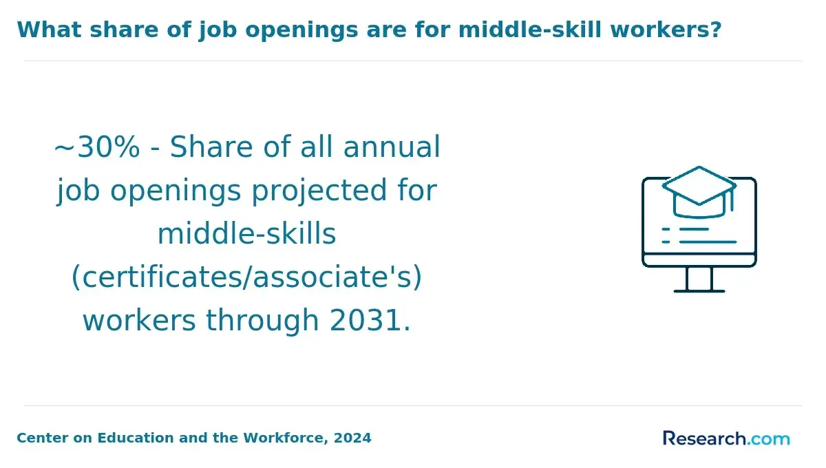
The ROI of a cheap online GIS bachelor’s degree depends on how much you pay, how quickly you graduate, how much debt you take on, and whether the program helps you qualify for GIS-related roles. A low-cost accredited degree can produce a strong return when it leads to stable employment in fields such as geospatial analysis, urban planning, environmental science, utilities, transportation, public safety, or government.
Return on investment in higher education is calculated by comparing the total expense of a degree, including tuition, fees, and materials, with expected career earnings. For online GIS bachelor’s programs, ROI is often stronger when students reduce costs through transfer credits, grants, scholarships, employer support, or accelerated completion.
According to reports from the Georgetown University Center on Education and the Workforce and Payscale, the average ROI for bachelor’s degrees is about 3.0 over 20 years. Many affordable online GIS programs exceed this level because they combine lower costs with median mid-career salaries between $60,000 and $80,000.
- Cost efficiency: Lower tuition reduces the amount students must borrow, helping graduates keep more of their earnings after graduation.
- Salary potential: GIS careers can offer solid mid-career salaries, especially for graduates with skills in analytics, remote sensing, databases, planning, or geospatial data science.
- Benchmark advantage: Budget-friendly GIS programs may outperform the national average ROI for bachelor’s degrees when students avoid high debt and enter relevant roles.
- Payoff period: Graduates often recoup their investment faster, typically within 10 years, especially when they use transfer credits and financial aid to lower total cost.
- Industry stability: Continued demand for GIS professionals supports long-term earning potential across public, private, and nonprofit sectors.
- Program quality: ROI is not only about low tuition. A program with weak advising, limited GIS tools, or little project-based learning may cost less but provide weaker career value.
The strongest ROI usually comes from choosing an accredited program, minimizing debt, building a GIS portfolio, completing internships or applied projects, and targeting specializations with clear labor market demand.
What Graduates Say About Earning the Cheapest Online GIS Bachelor's Degree That Pays Well
- Grant: "Choosing the online GIS bachelor's degree program was driven by my need for flexibility while working full-time. The affordable tuition made it accessible without overwhelming my finances, and the practical skills I gained opened doors to new roles within my company that I hadn't previously qualified for. I'm genuinely grateful for how this program balanced convenience, cost, and career advancement."
- Harlan: "Reflecting on my experience, the online GIS bachelor's degree program offered a cost-effective path that didn't sacrifice quality. I appreciated the curriculum's focus on real-world applications, which deepened my understanding and confidence in the field. Since graduating, I've noticed a significant boost in my professional credibility and opportunities for leadership roles."
- Archer: "From a professional standpoint, pursuing the online GIS bachelor's degree program was a strategic investment that paid off quickly. The program's affordability combined with a robust support system helped me stay motivated through challenging coursework. The credentials I earned have not only advanced my career but also expanded my network within the industry."
Other Things You Should Know About GIS Degrees
Some online GIS bachelor's degree programs in 2027 require students to attend short in-person residencies for workshops or exams. These residencies often occur annually or biannually and are typically held on campus or at designated locations.
Yes, some institutions offer fully online GIS bachelor's programs without out-of-state tuition penalties. For instance, certain public universities provide the same tuition rates for all online students, regardless of residency, making these programs more accessible and affordable.
Several online GIS bachelor's programs in 2027 integrate experiential learning or internships, enhancing real-world skills. Programs such as those at universities with strong industry ties often include mandatory internships, providing students valuable experience that can boost employability and potential earnings.
References
- Finding the ROI of Online Programs -- Campus Technology https://campustechnology.com/articles/2017/07/19/finding-the-roi-of-online-programs.aspx
- Cost of Online Education vs. Traditional Education [2025]: Comparison https://educationdata.org/cost-of-online-education-vs-traditional-education
- 2025 Most Affordable Online Geographic Information Systems Degrees https://www.onlineu.com/most-affordable-colleges/geographic-information-systems-degrees
- Which route will provide the best education and return on investment for a GIS career? https://gis.stackexchange.com/questions/126553/which-route-will-provide-the-best-education-and-return-on-investment-for-a-gis-c
- 4 Ways Transfer Students Can Maximize College Credits for Prior Experience https://www.umassglobal.edu/blog-news/4-ways-transfer-students-can-maximize-college-credits-prior-experience
- Why certification? https://gis.ksu.edu/academics/certification.html
- Accreditation for eLearning Solution Providers https://www.qahe.org/accreditation-for-elearning-solution-providers/
- Best Online Geographic Information Systems Bachelor's Degree Programs, Jobs, and Salaries https://careerkarma.com/blog/best-online-geographic-information-systems-bachelors-degrees/
- Online degrees offer a better return on investment but little chance of getting rich https://qz.com/108289/online-degrees-offer-a-better-return-on-investment-but-little-chance-of-getting-rich
- Best Online Bachelor's in GIS Degrees - GISDegree.org https://www.gisdegree.org/online/bachelors/