2027 Remote Work Report for Geographic Information Systems Graduates: Flexible Roles, Pay, and Hiring Trends

Co-Founder and Chief Data Scientist
New Geographic Information Systems graduates often find remote job hunting confusing due to how specialized their skills are. Employers look for candidates who can manage spatial data alongside remote collaboration tools, a combination not all graduates master equally. Despite 35% of GIS-related positions offering flexible or fully remote work according to current US workforce studies, understanding which roles fit a remote setup remains unclear.
Salary ranges vary widely depending on industry and technical proficiency, adding another layer of complexity for new entrants. This article examines the remote job landscape, expected pay, and hiring patterns to provide clear guidance on navigating remote work opportunities in the Geographic Information Systems field.
Key Points About Working Remotely for Geographic Information Systems Graduates
- The average annual salary for remote Geographic Information Systems roles ranges from $70,000 to $90,000, varying with experience and job functions. This pay scale reflects market demand and specialization, guiding graduates on expected compensation in remote positions.
- Typical remote GIS roles include spatial data analyst, GIS developer, remote sensing specialist, and GIS consultant. These positions demand strong data interpretation, software proficiency, and client communication skills critical for distributed work environments.
- Graduates should prioritize building technical skills in key GIS platforms and mastering remote communication. Early preparation aligns with employer expectations and improves hiring prospects, as remote GIS roles often require proven capabilities before onboarding.
- Are there remote work opportunities in the Geographic Information Systems industry? Remote Opportunities
- Which Geographic Information Systems niches offer remote roles? Which Geographic Information Systems niches offer remote roles?
- What entry-level Geographic Information Systems roles allow remote work? Entry-Level Roles
- What is the average salary of Geographic Information Systems graduates who are working remotely? Average Salary
- Do remote Geographic Information Systems jobs pay the same as on-site roles? Pay Comparison
- What benefits do remote Geographic Information Systems employees receive? What benefits do remote Geographic Information Systems employees receive?
- Where can Geographic Information Systems graduates look for remote jobs? Where to Find Jobs
- What do Geographic Information Systems employers look for in candidates? What do Geographic Information Systems employers look for in candidates?
- How can Geographic Information Systems graduates prepare for remote roles? Preparing for Remote Roles
- How can Geographic Information Systems graduates if remote roles are a good fit for them? How can Geographic Information Systems graduates if remote roles are a good fit for them?
Are there remote work opportunities in the Geographic Information Systems industry?
Remote work opportunities in the Geographic Information Systems industry remain selective, especially for new graduates. Approximately 20% of entry-level GIS roles are fully remote, while about 50% offer hybrid models requiring some in-office presence. This split reflects employer needs to balance collaborative tasks with flexible arrangements.
Variations in remote work largely depend on regional compliance laws and organizational workflows. Employers in regions with stricter labor policies often maintain more on-site requirements for entry-level GIS positions, limiting telecommuting. Conversely, some companies leverage cloud-based GIS platforms to facilitate remote contributions, though in-person coordination remains essential for specific projects.
A notable 42.7% of firms across sectors require partial on-site attendance post-pandemic, according to a recent study, emphasizing that GIS employers follow this trend. Graduates should anticipate hybrid roles that demand adaptability and digital GIS skill proficiency rather than expecting fully remote positions immediately.
For example, a recent GIS graduate working for an environmental consulting firm may analyze data remotely but must join periodic field visits and team meetings on-site. This practical approach balances operational accuracy with flexible work expectations.
Which Geographic Information Systems niches offer remote roles?
Remote work opportunities in Geographic Information Systems are concentrated in roles that rely heavily on digital tools, cloud platforms, and data interpretation rather than physical fieldwork. A transportation planner, for example, can optimize city traffic flow by analyzing GIS data remotely, relying on real-time data feeds and software tools rather than frequent site visits.
Not all niches offer equivalent remote flexibility; positions that require extensive on-site data collection limit this option. Here are the most remote-friendly Geographic Information Systems niches and why they suit asynchronous or off-site work environments:
- Cartography and Map Design: This niche focuses on visualizing spatial data. Since design software and GIS platforms are primarily accessible online, professionals can efficiently complete projects from any location without compromising collaboration.
- Spatial Data Analysis: Specialists use statistical evaluation and programming to assess geospatial datasets. Their reliance on coding and data manipulation software supports well-structured remote workflows and team coordination over cloud platforms.
- Environmental GIS: Experts monitor natural resources and assess environmental impacts. Although some field data collection is necessary, much of the data management and interpretation happens remotely, supporting hybrid arrangements.
- Urban Planning GIS: Practitioners employ spatial modeling for infrastructure and public services. Increasing use of cloud computing tools enables effective remote collaboration and project management in this sector.
- Remote Sensing GIS: This area involves analyzing satellite and aerial imagery. While on-site image capture is essential, image processing and interpretation can be done remotely, offering flexible work options.
- Transportation and Logistics GIS: These professionals optimize routing and network efficiency using real-time data integration tools. The nature of the work supports distributed teams operating asynchronously.
- GIS Software Development: Creating and maintaining GIS applications is software-centric and thus inherently suited to remote work, aligning with broader trends in the tech sector.
A 2024 labor market analysis reports an 18.7% increase in remote-friendly job openings, especially in spatial data analysis and GIS software development roles. This growth reflects employer confidence in secure cloud-based workflows and signals strong Remote Geographic Information Systems job opportunities for graduates.
Still, the occasional need for on-site presence in environmental and remote sensing roles means graduates must carefully consider tradeoffs. Those seeking Flexible remote roles for Geographic Information Systems graduates should evaluate niches based on personal career aims and realistic work conditions to leverage remote work benefits optimally.
For detailed educational pathways aligned with future workforce demands, researching the best college majors for the future can provide actionable guidance.
What entry-level Geographic Information Systems roles allow remote work?
Entry-level Geographic Information Systems remote positions often require skill sets that allow professionals to work independently while managing detailed spatial data. Positions like GIS Technician or Remote Sensing Analyst demand proficiency in specialized software and data validation, critical for supporting hybrid or fully remote workplaces.
For instance, a junior GIS Technician employed by an environmental consulting firm can gather field data remotely and update spatial databases asynchronously, which fits a flexible schedule without compromising data integrity. The following roles illustrate common remote job opportunities for Geographic Information Systems graduates and highlight their core responsibilities.
- GIS Technician: Focuses on collecting, verifying, and organizing geospatial data. Entry-level candidates should be skilled in ArcGIS Pro and data editing tools. Remote work is effective because data compilation and simple map production can be done with minimal supervision.
- GIS Data Analyst: Involves analyzing spatial datasets to generate actionable insights. Familiarity with QGIS and Python scripting aids automation. This role suits remote settings as most analysis and reporting are digital tasks requiring independent problem-solving.
- Cartographic Technician: Creates map visuals and layouts for presentations. Candidates need strong design sense and software like ArcGIS Online or ERDAS Imagine. Remote work fits well due to the project-based nature of map creation and digital file delivery.
- Remote Sensing Analyst: Processes satellite or aerial imagery to extract useful information. Basic understanding of remote sensing software and image correction is essential. Tasks are technical but can be performed remotely with access to cloud GIS platforms.
- GIS Developer (Junior): Supports GIS application development and automation scripts. Requires coding skills, especially in Python or JavaScript. Remote feasibility is high because programming tasks only require computer access and virtual collaboration tools.
- Geospatial Data Specialist: Manages large spatial databases and ensures data quality. Entry-level roles value certification in Esri's ArcGIS or cloud GIS platforms. Remote work is practical due to independent data management and virtual team coordination.
Recent labor market data shows junior GIS Technician roles comprise nearly 35% of remote Geographic Information Systems job postings, indicating strong demand for these flexible positions. Candidates should balance software proficiency with independent data management skills to leverage remote opportunities effectively. Those pursuing remote job opportunities for Geographic Information Systems graduates must also consider factors like certification and real-world tool use as key differentiators.
Costs associated with technical GIS education vary, but understanding an accounting degree cost can provide a useful reference point for budgeting strategies in related fields where flexible remote roles are available.
What is the average salary of Geographic Information Systems graduates who are working remotely?
Geographic Information Systems graduates working remotely usually start with median salaries between $52,000 and $60,000 annually. Entry-level roles provide slightly lower pay than on-site jobs, reflecting trade-offs related to flexibility and reduced employer overhead. These averages set the baseline for remote compensation expectations in this field.
Salary variations depend heavily on the technical demands of roles and certifications held. Many employers remain cautious about increasing starting pay without demonstrable project experience or specialized credentials. A 2024 workforce study found that 63% of entry-level remote GIS positions offer salaries below $55,500, indicating cautious but growing acceptance of remote pay scales among technical fields.
Compared to similar sectors like environmental science or urban planning, GIS remote salaries are competitive though not significantly higher. Entry-level wages in those fields generally range from $48,000 to $58,000, positioning GIS graduates advantageously while still facing common remote-work compensation challenges.
GIS graduates considering remote positions must balance the benefits of flexible schedules against initial wage limitations. Skill development and project portfolio strength matter more for long-term growth than starting salaries alone. Prospective workers exploring career alternatives may also find value in programs such as online paralegal programs, which reflect the increasing demand for flexible, credentialed roles across various industries.
Do remote Geographic Information Systems jobs pay the same as on-site roles?
Remote Geographic Information Systems jobs typically pay about 8.7% less than comparable on-site roles. This gap reflects employers' location-based compensation strategies, which adjust salaries according to the employee's geographic cost of living rather than offering uniform national pay. For example, a remote GIS analyst living in a smaller metro area might earn less than one working on-site in a major city with higher living costs.
Many companies still follow location-based pay bands; a workforce report found that 62% of employers rely on these structures despite increased remote work adoption. This often means home-office allowances replace travel stipends but seldom cover the overall salary reduction. Such policies create persistent wage differences that graduates should carefully consider when choosing remote GIS roles.
GIS graduates weighing remote versus on-site positions must assess how geographic pay localization impacts long-term earning potential. Although remote work offers flexibility, the financial trade-offs can be significant depending on the employer's compensation framework and region-specific salaries.
What benefits do remote Geographic Information Systems employees receive?
Remote Geographic Information Systems employees often receive benefits tailored to overcome the challenges of decentralized work settings. Companies recognize that maintaining productivity and engagement remotely demands more than traditional offerings.
For example, a mid-sized GIS consultancy recently expanded its remote employee benefits after staff reported difficulties in securing ergonomic office equipment on their own, addressing both well-being and output. The following list summarizes key benefit types essential for remote GIS roles.
- Home Office and Technology Stipends: Many organizations provide direct financial support for workspace setup and required technology. This perk reduces out-of-pocket expenses for monitors, software, and ergonomic furniture, which helps sustain efficient workflows outside a central office.
- Healthcare and Retirement Plans: Remote GIS workers typically access comprehensive health insurance and retirement options similar to on-site colleagues. These benefits contribute to long-term security and support worker retention across diverse geographic locations.
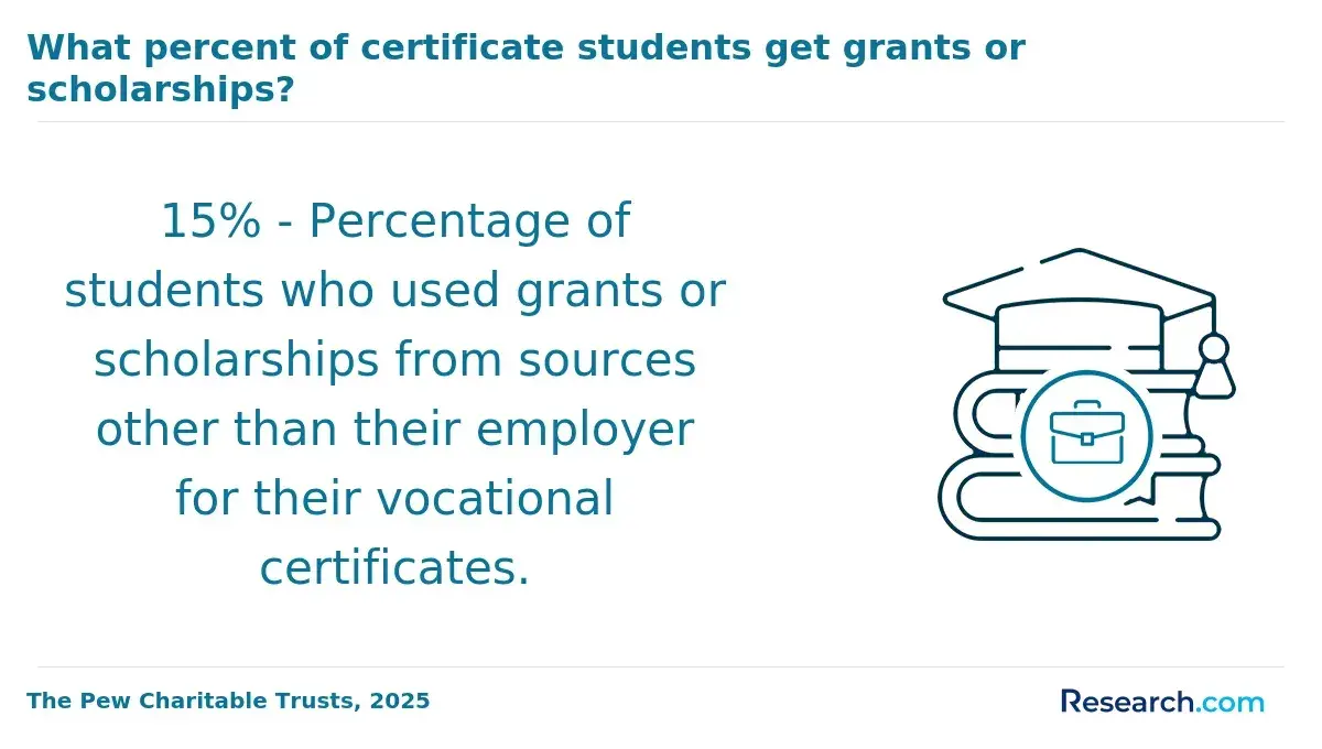
- Professional Certification Coverage: Nearly half of remote GIS employers allocate budgets for certification and continuing education. By funding credentials like GIS software training, companies maintain expertise vital to project success and innovation despite physical distance.
- Paid Time Off and Mental Health Days: Enhanced leave policies including mental health days respond to the potential isolation and stress of remote work. These provisions encourage work-life balance and lower burnout rates in a high-focus technical field.
A remote GIS analyst shared that receiving a recurring stipend for workspace expenses significantly changed their experience. Initially uncertain about investing in a quality setup, the stipend allowed them to create a dedicated home office without financial strain. This not only boosted daily productivity but also eased the stress of feeling constantly "on call," making remote work sustainable over time.
Where can Geographic Information Systems graduates look for remote jobs?
Finding remote positions in Geographic Information Systems requires mixing large-scale platforms with domain-specific resources to avoid the common trap of competing in oversaturated general job markets. For example, a recent graduate might start with LinkedIn for volume but fail to gain traction unless simultaneously engaging in specialized communities where employers seek targeted GIS skills.
Considering that about 42.7% of entry-level applications convert into interviews when candidates combine generic job boards with niche networks, leveraging a balanced set of channels is essential for breaking through initial hiring barriers.
Below are key online platforms and resources that GIS graduates should prioritize when searching for remote jobs:
- LinkedIn: A major job board offering a wide variety of remote GIS roles. It uses algorithmic matching based on profiles and skills, making it effective for reaching recruiters actively searching for candidates but requires strong profile curation and consistent networking to stand out.
- GIS Jobs Clearinghouse: A specialized site focusing exclusively on GIS and geospatial positions. Its curated listings attract employers looking for technical proficiency, offering fewer but more relevant remote opportunities that reduce wasted applications.
- Upwork: A freelance marketplace where GIS professionals can secure contract-based remote work. Its bidding system allows new entrants to build portfolios but demands a proactive approach to client outreach and does not guarantee long-term stability.
- Urban and Regional Information Systems Association (URISA): A professional network providing access to unadvertised remote openings and collaboration opportunities. Membership benefits include focused job postings and referrals, which enhance chances beyond typical public listings.
- Reddit r/gis and Discord Communities: Online groups that facilitate direct peer-to-peer job sharing, mentorship, and information on gigs often missed by large platforms. Their informal nature helps uncover emerging roles before they reach formal job boards.
What do Geographic Information Systems employers look for in candidates?
Geographic Information Systems employers prioritize candidates who combine technical proficiency with practical experience that enhances remote team productivity. In distributed work settings, the ability to translate spatial data into actionable insights is critical.
For example, a remote GIS analyst may be tasked with providing real-time environmental impact assessments using cloud-based platforms, requiring seamless communication and problem-solving at a distance. The specific qualifications sought by Geographic Information Systems employers can be grouped as follows:
- GIS Software Expertise: Proficiency in industry-standard tools such as Esri ArcGIS and QGIS is essential. Employers evaluate candidates' demonstrated ability to manipulate spatial data through these platforms, which form the backbone of most GIS workflows, ensuring consistent productivity regardless of physical location.
- Programming and Database Skills: Fluency in Python or R for geospatial data processing, alongside spatial database management, is highly valued. These skills enable automation and advanced analytics, which are crucial for remote positions that demand efficiency and scalability in data handling.
- Certifications and Tool Validation: Certifications such as Esri Technical Certification are often used as objective benchmarks. Recruiters rely on these credentials to quickly verify applied expertise, reducing hiring risk in distributed environments.
- Remote Sensing and Cloud Platform Knowledge: Familiarity with remote sensing technologies and cloud-based GIS services like Google Earth Engine or AWS geospatial tools reflects current industry trends. Candidates must adapt to cloud workflows to maintain relevance in a remote-first GIS job market.
- Communication and Collaborative Problem-Solving: Employers assess written and verbal communication through scenario-based interviews emphasizing asynchronous teamwork. This ensures candidates can effectively share insights and resolve geospatial challenges without real-time supervision.
Studies report that 68% of GIS-related remote roles demand advanced digital skills, including data science and cloud computing capabilities, signaling a shift from traditional GIS coursework toward multidisciplinary mastery. This trend indicates remote candidates must invest in continuous learning, such as following a data science learning path, to meet evolving employer expectations for Geographic Information Systems remote job requirements.
How can Geographic Information Systems graduates prepare for remote roles?
Preparation for remote roles in Geographic Information Systems requires deliberate skill expansion and practical readiness beyond traditional academic training. For example, a GIS analyst working on environmental planning may need to independently adapt cloud-based mapping tools and remotely coordinate analysis with a distributed team. The following strategies help graduates align their capabilities with the remote demands of flexible GIS employment.
- Advanced digital skills development: Gain proficiency in cloud platforms like ArcGIS Online and scripting languages such as Python for automation. This enables graduates to manage diverse datasets and troubleshoot issues without on-site support, a critical requirement in remote GIS roles.
- Targeted certifications and training: Completing courses focused on remote collaboration tools, spatial data science, and data visualization enhances employability. Recent studies show remote-readiness training increases GIS graduate job placement by 27%, proving the value of specialized credentials.
- Optimized hardware and software setup: Establish a reliable workspace with high-speed internet, multiple monitors, and licensed GIS software. Technical self-sufficiency assures employers of consistent productivity and reduces barriers related to remote supervision.
- Portfolio development with real-world projects: Build a collection of case studies like urban development spatial analyses to demonstrate end-to-end remote problem solving. A portfolio substantiates skills in practical contexts, crucial for distributed team hiring decisions.
- Familiarity with essential online certifications and tools: Engage in courses and software training specifically geared toward remote GIS workflows. This focused preparation addresses unique challenges in flexible employment environments and increases market readiness.
Many Geographic Information Systems graduates also explore a cheap online general studies degree to complement their technical expertise with broader academic flexibility. Integrating both skill development and credentials tailored for remote employment positions graduates competitively in the evolving GIS workforce.
How can Geographic Information Systems graduates if remote roles are a good fit for them?
Assessing the suitability of remote roles requires Geographic Information Systems graduates to critically appraise their work style, technical skills, and professional needs. For example, a recent graduate managing a complex spatial analysis project independently must gauge if they can maintain consistent focus and resolve software issues without on-site support.
The decision hinges on practical factors that shape daily workflows and long-term engagement. Below are key criteria graduates should evaluate to determine remote role fit:
- Self-Discipline and Time Management: Remote GIS work demands a high degree of personal accountability since supervisors are not physically present to monitor progress. Graduates who struggle with structure should consider if they can proactively organize tasks and meet deadlines independently to avoid falling behind.
- Technical Proficiency and Troubleshooting: Handling large geospatial datasets and specialized software at home means graduates must be comfortable navigating technical problems alone. Assessing one's ability to troubleshoot and optimize personal hardware setups is essential for smooth project delivery.
- Digital Communication Skills: Effective remote collaboration relies on clear, timely communication using digital platforms. Evaluating comfort level with virtual meetings, asynchronous feedback, and written reporting helps prevent misunderstandings that can disrupt workflow.
- Need for Mentorship and Feedback: Early-career GIS employees often benefit from in-person guidance. Graduates should realistically assess how the absence of face-to-face mentoring may affect their skill growth and whether they can seek feedback proactively through alternative channels.
- Comfort with Data Security Protocols: Remote GIS roles often require secure handling of sensitive spatial data, which may involve complex home network setups. Graduates must be prepared to comply with these protocols, or risk compromising data confidentiality.
- Social and Professional Interaction Preferences: Working remotely can limit peer contact and spontaneous brainstorming. Graduates who prioritize regular interpersonal exchange should consider how isolation might impact motivation and knowledge-sharing.
- Adaptability to Asynchronous Workflows: Many remote GIS teams operate asynchronously. Graduates need to evaluate their ability to manage work without immediate responses and to maintain productivity despite time zone differences.
A graduate from an online Geographic Information Systems degree shared how she settled into remote work after initially doubting her ability to stay engaged without office camaraderie.
She recalls, "I hesitated at first because I relied on quick chats with mentors to fix software glitches. Once I committed, I set strict daily goals and scheduled regular check-ins with my team. That structure helped me build confidence managing projects solo, while still feeling connected through virtual collaborations."
Her experience highlights how intentional planning and realistic self-assessment enable successful adaptation to remote GIS careers.
References
- GIS tools for schools | Education | OS https://www.ordnancesurvey.co.uk/education/gis-schools
- Bachelor of Applied Technology Geographic Information Systems https://www.sait.ca/programs-and-courses/degrees/bachelor-of-applied-technology-geographic-information-systems
- Geographic Information Systems Technology Degree, AAS | SJC https://www.sanjuancollege.edu/education-training/programs/geo-info-systems-aas/
- 9 Questions to Ask When Evaluating GIS Software | BioMedware https://biomedware.com/9-questions-to-ask-when-evaluating-gis-software/
- GIS (Geographic Information System) https://education.nationalgeographic.org/resource/geographic-information-system-gis/
- 2025 Best Online GIS Degrees https://www.onlineu.com/degrees/geographic-information-systems
- Best Online Bachelor's in GIS Degrees - GISDegree.org https://www.gisdegree.org/online/bachelors/
- Geographic Information Systems | Free Online Course | Alison https://alison.com/course/advanced-diploma-in-geographic-information-systems
- GIS Degree | GIS Certificate and Master's Online https://www.discoverdatascience.org/related-programs/gis/
Other Things You Should Know About Geographic Information Systems
Remote work in Geographic Information Systems often demands stronger proficiency in digital communication tools and self-management than on-site roles. Graduates must quickly learn to navigate asynchronous feedback and document sharing, which can delay problem-solving without immediate peer or supervisor access. Prioritizing development of clear reporting and independent troubleshooting skills is essential, as employers expect remote employees to resolve many issues before escalating.
Remote roles frequently involve less direct oversight, so balancing workload depends heavily on personal time management and prioritization, especially when juggling multiple projects with varying deadlines. Graduates should recognize that remote employers may assign broader responsibilities with an expectation of autonomy, making it critical to develop systems for tracking progress and setting boundaries to avoid burnout.
Those less confident in self-regulation might struggle without structured environments.
Yes, graduates aiming for advancement should consider remote roles with employers that offer structured mentorship or formal upskilling programs, as these are less common in fully distributed teams.
Startups may provide flexible schedules but often lack comprehensive training, whereas established firms might invest in continuous professional development despite remote settings. Prioritizing employers who document workflows and support skill growth can prevent stagnation in technical expertise and career progression.
Remote Geographic Information Systems work typically limits organic networking opportunities that happen naturally on-site, which can slow growth in industry connections critical for future job prospects. Graduates should proactively engage in virtual industry events or specialized forums to bridge this gap; passive reliance on day-to-day interaction with colleagues is insufficient.
Strategically investing time in online communities or certifications linked to professional bodies can compensate for reduced face-to-face engagement.